Tieste-Uragnoux
Tieste-Uragnoux | |
|---|---|
show Location of Tieste-Uragnoux | |
 Tieste-Uragnoux | |
| Coordinates: 43°33′01″N 0°02′19″E / 43.5503°N 0.0386°ECoordinates: 43°33′01″N 0°02′19″E / 43.5503°N 0.0386°E | |
| Country | France |
| Region | Occitanie |
| Department | Gers |
| Arrondissement | Mirande |
| Canton | Pardiac-Rivière-Basse |
| Intercommunality | Bastides et vallons du Gers |
| Government | |
| • Mayor (2020–2026) | Carole Arroyo |
| Area 1 | 6.1 km2 (2.4 sq mi) |
| Population (Jan. 2018)[1] | 162 |
| • Density | 27/km2 (69/sq mi) |
| Time zone | UTC+01:00 (CET) |
| • Summer (DST) | UTC+02:00 (CEST) |
| INSEE/Postal code | 32445 /32160 |
| Elevation | 144–224 m (472–735 ft) (avg. 160 m or 520 ft) |
| 1 French Land Register data, which excludes lakes, ponds, glaciers > 1 km2 (0.386 sq mi or 247 acres) and river estuaries. | |


Tieste-Uragnoux (French pronunciation: [tjɛst yʁaɲu]; Occitan: Tièste e Los Uranhós) is a commune in the Gers department in southwestern France.
Geography[]
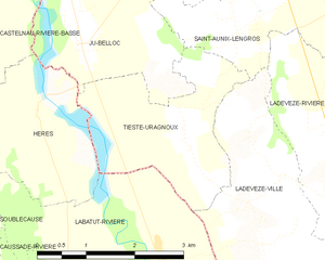
Tieste-Uragnoux and its surrounding communes
Population[]
| Year | Pop. | ±% |
|---|---|---|
| 1962 | 130 | — |
| 1968 | 129 | −0.8% |
| 1975 | 128 | −0.8% |
| 1982 | 144 | +12.5% |
| 1990 | 118 | −18.1% |
| 1999 | 121 | +2.5% |
| 2008 | 130 | +7.4% |
See also[]
- Communes of the Gers department
References[]
- ^ "Populations légales 2018". INSEE. 28 December 2020.
| Wikimedia Commons has media related to Tieste-Uragnoux. |
| show Communes of the Gers department |
|---|
This Gers geographical article is a stub. You can help Wikipedia by . |
Categories:
- Communes of Gers
- Gers geography stubs