Saint-Georges, Gers
Saint-Georges | |
|---|---|
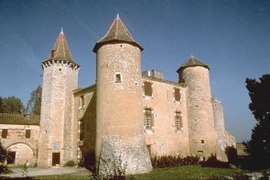 Chateau of Le Bartas | |
show Location of Saint-Georges | |
 Saint-Georges | |
| Coordinates: 43°43′43″N 0°56′13″E / 43.7286°N 0.9369°ECoordinates: 43°43′43″N 0°56′13″E / 43.7286°N 0.9369°E | |
| Country | France |
| Region | Occitanie |
| Department | Gers |
| Arrondissement | Condom |
| Canton | Gimone-Arrats |
| Government | |
| • Mayor (2008–2014) | Daniel Labissy |
| Area 1 | 15.82 km2 (6.11 sq mi) |
| Population (Jan. 2018)[1] | 180 |
| • Density | 11/km2 (29/sq mi) |
| Time zone | UTC+01:00 (CET) |
| • Summer (DST) | UTC+02:00 (CEST) |
| INSEE/Postal code | 32377 /32430 |
| Elevation | 120–212 m (394–696 ft) (avg. 200 m or 660 ft) |
| 1 French Land Register data, which excludes lakes, ponds, glaciers > 1 km2 (0.386 sq mi or 247 acres) and river estuaries. | |


Saint-Georges (Occitan: Sent Jòrdi) is a commune in the Gers department in southwestern France.
Geography[]
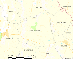
Saint-Georges and its surrounding communes
Population[]
| Year | Pop. | ±% |
|---|---|---|
| 1962 | 236 | — |
| 1968 | 195 | −17.4% |
| 1975 | 180 | −7.7% |
| 1982 | 162 | −10.0% |
| 1990 | 181 | +11.7% |
| 1999 | 154 | −14.9% |
| 2008 | 170 | +10.4% |
See also[]
- Communes of the Gers department
References[]
- ^ "Populations légales 2018". INSEE. 28 December 2020.
| Wikimedia Commons has media related to Saint-Georges (Gers). |
| show Communes of the Gers department |
|---|
This Gers geographical article is a stub. You can help Wikipedia by . |
Categories:
- Communes of Gers
- Gers geography stubs