Saint-Léonard, Gers
Saint-Léonard | |
|---|---|
show Location of Saint-Léonard | |
 Saint-Léonard | |
| Coordinates: 43°51′35″N 0°46′11″E / 43.8597°N 0.7697°ECoordinates: 43°51′35″N 0°46′11″E / 43.8597°N 0.7697°E | |
| Country | France |
| Region | Occitanie |
| Department | Gers |
| Arrondissement | Condom |
| Canton | Fleurance-Lomagne |
| Government | |
| • Mayor (2020–2026) | Gervais Molas[1] |
| Area 1 | 13.11 km2 (5.06 sq mi) |
| Population (Jan. 2018)[2] | 183 |
| • Density | 14/km2 (36/sq mi) |
| Time zone | UTC+01:00 (CET) |
| • Summer (DST) | UTC+02:00 (CEST) |
| INSEE/Postal code | 32385 /32380 |
| Elevation | 96–192 m (315–630 ft) (avg. 192 m or 630 ft) |
| 1 French Land Register data, which excludes lakes, ponds, glaciers > 1 km2 (0.386 sq mi or 247 acres) and river estuaries. | |


Saint-Léonard is a commune in the Gers department in southwestern France.
Geography[]
The river Auroue forms all of the commune's western border.
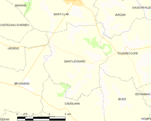
Saint-Léonard and its surrounding communes
Population[]
| Year | Pop. | ±% |
|---|---|---|
| 1962 | 224 | — |
| 1968 | 208 | −7.1% |
| 1975 | 190 | −8.7% |
| 1982 | 179 | −5.8% |
| 1990 | 161 | −10.1% |
| 1999 | 143 | −11.2% |
| 2008 | 170 | +18.9% |
See also[]
- Communes of the Gers department
References[]
- ^ "Répertoire national des élus: les maires". data.gouv.fr, Plateforme ouverte des données publiques françaises (in French). 2 December 2020.
- ^ "Populations légales 2018". INSEE. 28 December 2020.
| Wikimedia Commons has media related to Saint-Léonard (Gers). |
| show Communes of the Gers department |
|---|
This Gers geographical article is a stub. You can help Wikipedia by . |
Categories:
- Communes of Gers
- Gers geography stubs