Sarragachies
Sarragachies | |
|---|---|
 The church | |
show Location of Sarragachies | |
 Sarragachies | |
| Coordinates: 43°41′02″N 0°03′10″W / 43.6839°N 0.0528°WCoordinates: 43°41′02″N 0°03′10″W / 43.6839°N 0.0528°W | |
| Country | France |
| Region | Occitanie |
| Department | Gers |
| Arrondissement | Mirande |
| Canton | Adour-Gersoise |
| Government | |
| • Mayor (2020–2026) | Laurent Perisse |
| Area 1 | 12.83 km2 (4.95 sq mi) |
| Population (Jan. 2018)[1] | 234 |
| • Density | 18/km2 (47/sq mi) |
| Time zone | UTC+01:00 (CET) |
| • Summer (DST) | UTC+02:00 (CEST) |
| INSEE/Postal code | 32414 /32400 |
| Elevation | 106–177 m (348–581 ft) (avg. 155 m or 509 ft) |
| 1 French Land Register data, which excludes lakes, ponds, glaciers > 1 km2 (0.386 sq mi or 247 acres) and river estuaries. | |


Sarragachies (French pronunciation: [saʁaɡaʃi]; Occitan: Sarragaishias) is a commune in the Gers department in southwestern France.
Geography[]
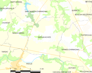
Sarragachies and its surrounding communes
Population[]
| Year | Pop. | ±% |
|---|---|---|
| 1962 | 303 | — |
| 1968 | 312 | +3.0% |
| 1975 | 319 | +2.2% |
| 1982 | 296 | −7.2% |
| 1990 | 271 | −8.4% |
| 1999 | 265 | −2.2% |
| 2008 | 256 | −3.4% |
See also[]
- Communes of the Gers department
References[]
- ^ "Populations légales 2018". INSEE. 28 December 2020.
| Wikimedia Commons has media related to Sarragachies. |
| show Communes of the Gers department |
|---|
This Gers geographical article is a stub. You can help Wikipedia by . |
Categories:
- Communes of Gers
- Gers geography stubs