Montaut-les-Créneaux
Montaut-les-Créneaux | |
|---|---|
 A general view of Montaut-les-Créneaux | |
show Location of Montaut-les-Créneaux | |
 Montaut-les-Créneaux | |
| Coordinates: 43°41′41″N 0°39′31″E / 43.6947°N 0.6586°ECoordinates: 43°41′41″N 0°39′31″E / 43.6947°N 0.6586°E | |
| Country | France |
| Region | Occitanie |
| Department | Gers |
| Arrondissement | Auch |
| Canton | Gascogne-Auscitaine |
| Intercommunality | Grand Auch |
| Government | |
| • Mayor (2020–2026) | Emmanuel Gallina |
| Area 1 | 26.23 km2 (10.13 sq mi) |
| Population (Jan. 2018)[1] | 709 |
| • Density | 27/km2 (70/sq mi) |
| Time zone | UTC+01:00 (CET) |
| • Summer (DST) | UTC+02:00 (CEST) |
| INSEE/Postal code | 32279 /32810 |
| Elevation | 114–264 m (374–866 ft) (avg. 244 m or 801 ft) |
| 1 French Land Register data, which excludes lakes, ponds, glaciers > 1 km2 (0.386 sq mi or 247 acres) and river estuaries. | |


Montaut-les-Créneaux (French pronunciation: [mɔ̃to lɛ kʁeno]; Occitan: Montaut) is a commune in the Gers department in southwestern France.
Geography[]
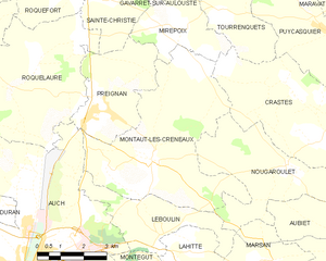
Montaut-les-Créneaux and its surrounding communes
Population[]
| Year | Pop. | ±% |
|---|---|---|
| 1962 | 521 | — |
| 1968 | 474 | −9.0% |
| 1975 | 433 | −8.6% |
| 1982 | 510 | +17.8% |
| 1990 | 612 | +20.0% |
| 1999 | 618 | +1.0% |
| 2008 | 626 | +1.3% |
See also[]
- Communes of the Gers department
References[]
- ^ "Populations légales 2018". INSEE. 28 December 2020.
| Wikimedia Commons has media related to Montaut-les-Créneaux. |
| show Communes of the Gers department |
|---|
| show Authority control |
|---|
This Gers geographical article is a stub. You can help Wikipedia by . |
Categories:
- Communes of Gers
- Gers geography stubs