Battenans-Varin
Battenans-Varin | |
|---|---|
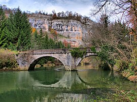 The bridge over the Dessoubre river in Battenans-Varin | |
Location of Battenans-Varin  | |
 Battenans-Varin  Battenans-Varin | |
| Coordinates: 47°14′59″N 6°42′46″E / 47.2497°N 6.7128°ECoordinates: 47°14′59″N 6°42′46″E / 47.2497°N 6.7128°E | |
| Country | France |
| Region | Bourgogne-Franche-Comté |
| Department | Doubs |
| Arrondissement | Montbéliard |
| Canton | Valdahon |
| Government | |
| • Mayor (2008–2014) | Christian Ramel |
| Area 1 | 6.38 km2 (2.46 sq mi) |
| Population (Jan. 2018)[1] | 75 |
| • Density | 12/km2 (30/sq mi) |
| Time zone | UTC+01:00 (CET) |
| • Summer (DST) | UTC+02:00 (CEST) |
| INSEE/Postal code | 25046 /25380 |
| Elevation | 408–740 m (1,339–2,428 ft) |
| 1 French Land Register data, which excludes lakes, ponds, glaciers > 1 km2 (0.386 sq mi or 247 acres) and river estuaries. | |
Battenans-Varin is a commune in the Doubs department in the Bourgogne-Franche-Comté region in eastern France.
Population[]
| Year | Pop. | ±% |
|---|---|---|
| 1962 | 84 | — |
| 1968 | 106 | +26.2% |
| 1975 | 78 | −26.4% |
| 1982 | 58 | −25.6% |
| 1990 | 64 | +10.3% |
| 1999 | 56 | −12.5% |
| 2008 | 52 | −7.1% |
| 2012 | 78 | +50.0% |
See also[]
References[]
- ^ "Populations légales 2018". INSEE. 28 December 2020.
| Wikimedia Commons has media related to Battenans-Varin. |
|
This Doubs geographical article is a stub. You can help Wikipedia by . |
Categories:
- Communes of Doubs
- Doubs geography stubs