Brères
Brères | |
|---|---|
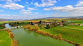 A general view of Brères and the Loue river | |
show Location of Brères | |
 Brères | |
| Coordinates: 47°03′34″N 5°51′38″E / 47.0594°N 5.8606°ECoordinates: 47°03′34″N 5°51′38″E / 47.0594°N 5.8606°E | |
| Country | France |
| Region | Bourgogne-Franche-Comté |
| Department | Doubs |
| Arrondissement | Besançon |
| Canton | Saint-Vit |
| Intercommunality | Loue-Lison |
| Government | |
| • Mayor (2008–2014) | Jean-Claude Demesmay |
| Area 1 | 2.15 km2 (0.83 sq mi) |
| Population (Jan. 2018)[1] | 63 |
| • Density | 29/km2 (76/sq mi) |
| Time zone | UTC+01:00 (CET) |
| • Summer (DST) | UTC+02:00 (CEST) |
| INSEE/Postal code | 25090 /25440 |
| Elevation | 254–298 m (833–978 ft) |
| 1 French Land Register data, which excludes lakes, ponds, glaciers > 1 km2 (0.386 sq mi or 247 acres) and river estuaries. | |


Brères is a commune in the Doubs department in the Bourgogne-Franche-Comté region in eastern France.
Population[]
| Year | Pop. | ±% |
|---|---|---|
| 1962 | 34 | — |
| 1968 | 32 | −5.9% |
| 1975 | 26 | −18.8% |
| 1982 | 24 | −7.7% |
| 1990 | 28 | +16.7% |
| 1999 | 35 | +25.0% |
| 2008 | 32 | −8.6% |
| 2012 | 47 | +46.9% |
See also[]
References[]
- ^ "Populations légales 2018". INSEE. 28 December 2020.
| Wikimedia Commons has media related to Brères. |
This Doubs geographical article is a stub. You can help Wikipedia by . |
Categories:
- Communes of Doubs
- Doubs geography stubs