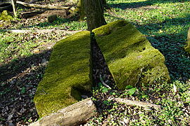
Gémonval
Gémonval | |
|---|---|
 A general view of Gémonval | |
show Location of Gémonval | |
 Gémonval | |
| Coordinates: 47°31′59″N 6°35′21″E / 47.5331°N 6.5892°ECoordinates: 47°31′59″N 6°35′21″E / 47.5331°N 6.5892°E | |
| Country | France |
| Region | Bourgogne-Franche-Comté |
| Department | Doubs |
| Arrondissement | Montbéliard |
| Canton | Bavans |
| Government | |
| • Mayor (2020–2026) | Fabrice Vrillacq[1] |
| Area 1 | 3.39 km2 (1.31 sq mi) |
| Population (Jan. 2018)[2] | 84 |
| • Density | 25/km2 (64/sq mi) |
| Time zone | UTC+01:00 (CET) |
| • Summer (DST) | UTC+02:00 (CEST) |
| INSEE/Postal code | 25264 /25250 |
| Elevation | 305–513 m (1,001–1,683 ft) |
| 1 French Land Register data, which excludes lakes, ponds, glaciers > 1 km2 (0.386 sq mi or 247 acres) and river estuaries. | |


Gémonval is a commune in the Doubs department in the Bourgogne-Franche-Comté region in eastern France.
Coal mines were operated in the village between 1826 and 1944.

Mine shaft of Elisabeth.

Mine shaft de la Houillère.

Mine shaft des Essarts.
Plinth of steam machine in mine shaft des Essarts.


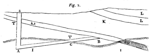
A sectional view of the mine-schaft #3.
ht : "houille tendre" (coal),
hg (gray) : "houille gypseuse" (coal).

Population[]
| Year | Pop. | ±% |
|---|---|---|
| 1962 | 76 | — |
| 1968 | 92 | +21.1% |
| 1975 | 75 | −18.5% |
| 1982 | 86 | +14.7% |
| 1990 | 100 | +16.3% |
| 1999 | 75 | −25.0% |
| 2008 | 88 | +17.3% |
| 2012 | 77 | −12.5% |
See also[]
References[]
- ^ "Répertoire national des élus: les maires". data.gouv.fr, Plateforme ouverte des données publiques françaises (in French). 2 December 2020.
- ^ "Populations légales 2018". INSEE. 28 December 2020.
| Wikimedia Commons has media related to Gémonval. |
This Doubs geographical article is a stub. You can help Wikipedia by . |
Categories:
- Communes of Doubs
- Doubs geography stubs