Val-de-Roulans
Val-de-Roulans | |
|---|---|
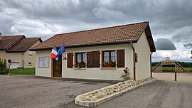 The town hall in Val-de-Roulans | |
show Location of Val-de-Roulans | |
 Val-de-Roulans | |
| Coordinates: 47°21′45″N 6°15′55″E / 47.3625°N 6.2653°ECoordinates: 47°21′45″N 6°15′55″E / 47.3625°N 6.2653°E | |
| Country | France |
| Region | Bourgogne-Franche-Comté |
| Department | Doubs |
| Arrondissement | Besançon |
| Canton | Baume-les-Dames |
| Government | |
| • Mayor (2008–2014) | Bernard Drezet |
| Area 1 | 2.99 km2 (1.15 sq mi) |
| Population (Jan. 2018)[1] | 200 |
| • Density | 67/km2 (170/sq mi) |
| Time zone | UTC+01:00 (CET) |
| • Summer (DST) | UTC+02:00 (CEST) |
| INSEE/Postal code | 25579 /25640 |
| Elevation | 364–423 m (1,194–1,388 ft) |
| 1 French Land Register data, which excludes lakes, ponds, glaciers > 1 km2 (0.386 sq mi or 247 acres) and river estuaries. | |


Val-de-Roulans is a commune in the Doubs department in the Bourgogne-Franche-Comté region in eastern France.
Population[]
| Year | Pop. | ±% |
|---|---|---|
| 1962 | 29 | — |
| 1968 | 41 | +41.4% |
| 1975 | 43 | +4.9% |
| 1982 | 50 | +16.3% |
| 1990 | 63 | +26.0% |
| 1999 | 84 | +33.3% |
| 2008 | 130 | +54.8% |
| 2012 | 169 | +30.0% |
See also[]
References[]
- ^ "Populations légales 2018". INSEE. 28 December 2020.
| Wikimedia Commons has media related to Val-de-Roulans. |
This Doubs geographical article is a stub. You can help Wikipedia by . |
Categories:
- Communes of Doubs
- Doubs geography stubs