Dasle
Dasle | |
|---|---|
Commune | |
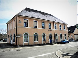 Town hall | |
show Location of Dasle | |
 Dasle | |
| Coordinates: 47°28′43″N 6°53′42″E / 47.4786°N 6.895°ECoordinates: 47°28′43″N 6°53′42″E / 47.4786°N 6.895°E | |
| Country | France |
| Region | Bourgogne-Franche-Comté |
| Department | Doubs |
| Arrondissement | Montbéliard |
| Canton | Audincourt |
| Intercommunality | Pays de Montbéliard Agglomération |
| Government | |
| • Mayor (2020–2026) | Carole Thouesny |
| Area 1 | 5.67 km2 (2.19 sq mi) |
| Population (Jan. 2018)[1] | 1,405 |
| • Density | 250/km2 (640/sq mi) |
| Time zone | UTC+01:00 (CET) |
| • Summer (DST) | UTC+02:00 (CEST) |
| INSEE/Postal code | 25196 /25230 |
| Elevation | 360–461 m (1,181–1,512 ft) |
| 1 French Land Register data, which excludes lakes, ponds, glaciers > 1 km2 (0.386 sq mi or 247 acres) and river estuaries. | |


Dasle (French pronunciation: [dal]) is a commune in the Doubs department in the Bourgogne-Franche-Comté region in eastern France.
Population[]
| Year | Pop. | ±% |
|---|---|---|
| 1962 | 1,316 | — |
| 1968 | 1,357 | +3.1% |
| 1975 | 1,345 | −0.9% |
| 1982 | 1,439 | +7.0% |
| 1990 | 1,418 | −1.5% |
| 1999 | 1,343 | −5.3% |
| 2008 | 1,367 | +1.8% |
| 2012 | 1,425 | +4.2% |
See also[]
References[]
- ^ "Populations légales 2018". INSEE. 28 December 2020.
| Wikimedia Commons has media related to Dasle. |
This Doubs geographical article is a stub. You can help Wikipedia by . |
Categories:
- Communes of Doubs
- County of Montbéliard
- Doubs geography stubs