Franois
Franois | |
|---|---|
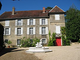 The chateau in Franois | |
show Location of Franois | |
 Franois | |
| Coordinates: 47°14′00″N 5°55′35″E / 47.2333°N 5.9264°ECoordinates: 47°14′00″N 5°55′35″E / 47.2333°N 5.9264°E | |
| Country | France |
| Region | Bourgogne-Franche-Comté |
| Department | Doubs |
| Arrondissement | Besançon |
| Canton | Besançon-1 |
| Intercommunality | Grand Besançon Métropole |
| Government | |
| • Mayor (2020–2026) | Émile Bourgeois |
| Area 1 | 7.29 km2 (2.81 sq mi) |
| Population (Jan. 2018)[1] | 2,318 |
| • Density | 320/km2 (820/sq mi) |
| Time zone | UTC+01:00 (CET) |
| • Summer (DST) | UTC+02:00 (CEST) |
| INSEE/Postal code | 25258 /25770 |
| Elevation | 248–312 m (814–1,024 ft) |
| 1 French Land Register data, which excludes lakes, ponds, glaciers > 1 km2 (0.386 sq mi or 247 acres) and river estuaries. | |


Franois (French pronunciation: [fʁanwa]) is a commune in the Doubs department in the Bourgogne-Franche-Comté region in eastern France
Population[]
| Year | Pop. | ±% |
|---|---|---|
| 1962 | 656 | — |
| 1968 | 888 | +35.4% |
| 1975 | 1,242 | +39.9% |
| 1982 | 1,293 | +4.1% |
| 1990 | 1,558 | +20.5% |
| 1999 | 1,779 | +14.2% |
| 2008 | 1,902 | +6.9% |
| 2012 | 2,031 | +6.8% |
References[]
| Wikimedia Commons has media related to Franois. |
- ^ "Populations légales 2018". INSEE. 28 December 2020.
This Doubs geographical article is a stub. You can help Wikipedia by . |
Categories:
- Communes of Doubs
- Doubs geography stubs