Orsans, Doubs
Orsans | |
|---|---|
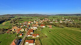 A general view of Orsans | |
show Location of Orsans | |
 Orsans | |
| Coordinates: 47°14′54″N 6°23′23″E / 47.2483°N 6.3897°ECoordinates: 47°14′54″N 6°23′23″E / 47.2483°N 6.3897°E | |
| Country | France |
| Region | Bourgogne-Franche-Comté |
| Department | Doubs |
| Arrondissement | Pontarlier |
| Canton | Valdahon |
| Intercommunality | Portes du Haut-Doubs |
| Government | |
| • Mayor (2008–2014) | Guy Parola |
| Area 1 | 8.29 km2 (3.20 sq mi) |
| Population (Jan. 2018)[1] | 162 |
| • Density | 20/km2 (51/sq mi) |
| Time zone | UTC+01:00 (CET) |
| • Summer (DST) | UTC+02:00 (CEST) |
| INSEE/Postal code | 25435 /25530 |
| Elevation | 500–630 m (1,640–2,070 ft) |
| 1 French Land Register data, which excludes lakes, ponds, glaciers > 1 km2 (0.386 sq mi or 247 acres) and river estuaries. | |


Orsans is a commune in the Doubs department in the Bourgogne-Franche-Comté region in eastern France.
Population[]
| Year | Pop. | ±% |
|---|---|---|
| 1962 | 117 | — |
| 1968 | 129 | +10.3% |
| 1975 | 112 | −13.2% |
| 1982 | 116 | +3.6% |
| 1990 | 102 | −12.1% |
| 1999 | 125 | +22.5% |
| 2006 | 160 | +28.0% |
| 2012 | 164 | +2.5% |
See also[]
References[]
- ^ "Populations légales 2018". INSEE. 28 December 2020.
| Wikimedia Commons has media related to Orsans (Doubs). |
This Doubs geographical article is a stub. You can help Wikipedia by . |
Categories:
- Communes of Doubs
- Doubs geography stubs