Bettencourt-Saint-Ouen
From Wikipedia, the free encyclopedia
Commune in Hauts-de-France, France
Bettencourt-Saint-Ouen | |
|---|---|
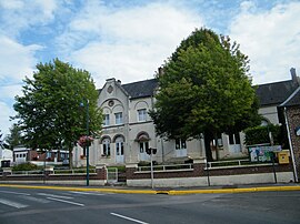 The town hall and school in Bettencourt-Saint-Ouen | |
 Bettencourt-Saint-Ouen  Bettencourt-Saint-Ouen | |
Coordinates:  50°01′35″N 2°06′44″E / 50.0264°N 2.1122°E / 50.0264; 2.1122Coordinates: 50°01′35″N 2°06′44″E / 50.0264°N 2.1122°E / 50.0264; 2.1122 50°01′35″N 2°06′44″E / 50.0264°N 2.1122°E / 50.0264; 2.1122Coordinates: 50°01′35″N 2°06′44″E / 50.0264°N 2.1122°E / 50.0264; 2.1122 | |
| Country | France |
| Region | Hauts-de-France |
| Department | Somme |
| Arrondissement | Amiens |
| Canton | Flixecourt |
| Intercommunality | CC Nièvre et Somme |
| Government | |
| • Mayor (2014–2020) | Michel Villain |
| Area 1 | 8.04 km2 (3.10 sq mi) |
| Population (Jan. 2018)[1] | 619 |
| • Density | 77/km2 (200/sq mi) |
| Time zone | UTC+01:00 (CET) |
| • Summer (DST) | UTC+02:00 (CEST) |
| INSEE/Postal code | 80100 /80610 |
| Elevation | 17–103 m (56–338 ft) (avg. 35 m or 115 ft) |
| 1 French Land Register data, which excludes lakes, ponds, glaciers > 1 km2 (0.386 sq mi or 247 acres) and river estuaries. | |

Bettencourt-Saint-Ouen is a commune in the Somme department and Hauts-de-France region of northern France.
Contents
Geography[]
The commune is situated on the D57 road, some 18 miles (29 km) northwest of Amiens and less than a mile from the A16 autoroute.
Population[]
| Year | 1962 | 1968 | 1975 | 1982 | 1990 | 1999 | 2006 | 2014 |
|---|---|---|---|---|---|---|---|---|
| Population | 356 | 377 | 340 | 345 | 389 | 410 | 496 | 637 |
| From the year 1962 on: No double counting—residents of multiple communes (e.g. students and military personnel) are counted only once. | ||||||||
See also[]
References[]
- ^ "Populations légales 2018". INSEE. 28 December 2020.
| Wikimedia Commons has media related to Bettencourt-Saint-Ouen. |
show
Communes of the Somme department | |
|---|---|
|
| show Authority control | |
|---|---|
| General |
|
| National libraries | |
This Arrondissement of Amiens geographical article is a stub. You can help Wikipedia by . |
- v
- t
Retrieved from ""
Categories:
- Communes of Somme (department)
- Amiens arrondissement geography stubs
Hidden categories:
- Articles with short description
- Short description is different from Wikidata
- Infobox mapframe without OSM relation ID on Wikidata
- Coordinates on Wikidata
- Pages using infobox settlement with image map1 but not image map
- Commons category link is on Wikidata
- Articles with VIAF identifiers
- Articles with BNF identifiers
- Articles with LCCN identifiers
- Articles with WorldCat-VIAF identifiers
- All stub articles
- Pages using the Kartographer extension