Fieffes-Montrelet
Fieffes-Montrelet | |
|---|---|
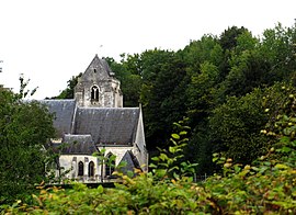 The church in Fieffes | |
show Location of Fieffes-Montrelet | |
 Fieffes-Montrelet | |
| Coordinates: 50°05′12″N 2°13′51″E / 50.0867°N 2.2308°ECoordinates: 50°05′12″N 2°13′51″E / 50.0867°N 2.2308°E | |
| Country | France |
| Region | Hauts-de-France |
| Department | Somme |
| Arrondissement | Amiens |
| Canton | Doullens |
| Intercommunality | CC Territoire Nord Picardie |
| Government | |
| • Mayor (2020–2026) | Xavier Varlet[1] |
| Area 1 | 9.68 km2 (3.74 sq mi) |
| Population (Jan. 2018)[2] | 334 |
| • Density | 35/km2 (89/sq mi) |
| Time zone | UTC+01:00 (CET) |
| • Summer (DST) | UTC+02:00 (CEST) |
| INSEE/Postal code | 80566 /80670 |
| Elevation | 63–147 m (207–482 ft) (avg. 98 m or 322 ft) |
| 1 French Land Register data, which excludes lakes, ponds, glaciers > 1 km2 (0.386 sq mi or 247 acres) and river estuaries. | |


Fieffes-Montrelet is a commune in the Somme department in Hauts-de-France in northern France.
Geography[]
The communes is situated on the D49 road, some 20 miles (32 km) east of Abbeville.
History[]
In 1975, the two communes of Fieffes and Montrelet were united to create a single administrative entity.
Population[]
| Year | 1962 | 1968 | 1975 | 1982 | 1990 | 1999 | 2006 |
|---|---|---|---|---|---|---|---|
| Population | 267 | 306 | 274 | 279 | 291 | 299 | 313 |
| From the year 1962 on: No double counting—residents of multiple communes (e.g. students and military personnel) are counted only once. | |||||||
Places of interest[]
- Fieffes church
The church of Saint-Pierre is in the Romanesque style. The altar has recently (2007) been restored at a cost of €7500
- Montrelet church
Surrounded by the graveyard, it is unusually aligned with the river and in a high position.

Wooden supports at Fieffes

The south gate at Fieffes

Montrelet church


See also[]
References[]
- ^ "Répertoire national des élus: les maires". data.gouv.fr, Plateforme ouverte des données publiques françaises (in French). 2 December 2020.
- ^ "Populations légales 2018". INSEE. 28 December 2020.
External links[]
| Wikimedia Commons has media related to Fieffes-Montrelet. |
| show Authority control |
|---|
Categories:
- Communes of Somme (department)
- Amiens arrondissement geography stubs