Frucourt
Frucourt | |
|---|---|
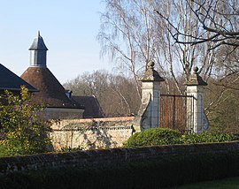 Dovecote | |
show Location of Frucourt | |
 Frucourt | |
| Coordinates: 49°59′47″N 1°48′36″E / 49.9964°N 1.81°ECoordinates: 49°59′47″N 1°48′36″E / 49.9964°N 1.81°E | |
| Country | France |
| Region | Hauts-de-France |
| Department | Somme |
| Arrondissement | Abbeville |
| Canton | Gamaches |
| Intercommunality | CA Baie de Somme |
| Government | |
| • Mayor (2020–2026) | Gilbert Duchemin[1] |
| Area 1 | 5.27 km2 (2.03 sq mi) |
| Population (Jan. 2018)[2] | 128 |
| • Density | 24/km2 (63/sq mi) |
| Time zone | UTC+01:00 (CET) |
| • Summer (DST) | UTC+02:00 (CEST) |
| INSEE/Postal code | 80372 /80490 |
| Elevation | 48–114 m (157–374 ft) (avg. 100 m or 330 ft) |
| 1 French Land Register data, which excludes lakes, ponds, glaciers > 1 km2 (0.386 sq mi or 247 acres) and river estuaries. | |


Frucourt (French pronunciation: [fʁyˈkuʁ]) is a commune in the Somme department in Hauts-de-France in northern France.
Geography[]
Frucourt is situated on the D93 road, some 10 miles (16 km) south of Abbeville.
Population[]
| Year | 1962 | 1968 | 1975 | 1982 | 1990 | 1999 | 2006 |
|---|---|---|---|---|---|---|---|
| Population | 147 | 155 | 165 | 162 | 142 | 121 | 135 |
| From the year 1962 on: No double counting—residents of multiple communes (e.g. students and military personnel) are counted only once. | |||||||
Places of interest[]
- The windmill, built in brick in 1641. The walls are 6 ft (1,80m) thick at the base. It bears the (defaced) armorial of the seigneurs of the château of Frucourt, the Monthomer family. In June 2004, it was completely renovated and won a heritage prize " Les Rubans du Patrimoine".
- The château
- The church
- The war memorial
See also[]
References[]
- ^ "Répertoire national des élus: les maires". data.gouv.fr, Plateforme ouverte des données publiques françaises (in French). 2 December 2020.
- ^ "Populations légales 2018". INSEE. 28 December 2020.
External links[]
| Wikimedia Commons has media related to Frucourt. |
- Section patrimoine des Amis du CIS d'Hallencourt (in French)
Categories:
- Communes of Somme (department)
- Abbeville arrondissement geography stubs