Grattepanche
Grattepanche | |
|---|---|
 The church in Grattepanche | |
show Location of Grattepanche | |
 Grattepanche | |
| Coordinates: 49°47′17″N 2°17′41″E / 49.7881°N 2.2947°ECoordinates: 49°47′17″N 2°17′41″E / 49.7881°N 2.2947°E | |
| Country | France |
| Region | Hauts-de-France |
| Department | Somme |
| Arrondissement | Amiens |
| Canton | Ailly-sur-Noye |
| Intercommunality | Amien Métropole |
| Government | |
| • Mayor (2020–2026) | Bruno Bardet[1] |
| Area 1 | 6.43 km2 (2.48 sq mi) |
| Population (Jan. 2018)[2] | 321 |
| • Density | 50/km2 (130/sq mi) |
| Time zone | UTC+01:00 (CET) |
| • Summer (DST) | UTC+02:00 (CEST) |
| INSEE/Postal code | 80387 /80680 |
| Elevation | 69–125 m (226–410 ft) (avg. 100 m or 330 ft) |
| 1 French Land Register data, which excludes lakes, ponds, glaciers > 1 km2 (0.386 sq mi or 247 acres) and river estuaries. | |


Grattepanche is a commune in the Somme department in Hauts-de-France in northern France.
Geography[]
Grattepanche is situated on the D75e road, some 10 miles (16 km) south of Amiens.
Population[]
| Year | 1962 | 1968 | 1975 | 1982 | 1990 | 1999 | 2006 |
|---|---|---|---|---|---|---|---|
| Population | 87 | 120 | 148 | 179 | 243 | 269 | 291 |
| From the year 1962 on: No double counting—residents of multiple communes (e.g. students and military personnel) are counted only once. | |||||||
Places of interest[]
- The church
- The war memorial
- The calvary
See also[]
References[]
- ^ "Répertoire national des élus: les maires". data.gouv.fr, Plateforme ouverte des données publiques françaises (in French). 2 December 2020.
- ^ "Populations légales 2018". INSEE. 28 December 2020.
External links[]
| Wikimedia Commons has media related to Grattepanche. |
- Official municipal website (in French)
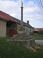
The calvary
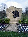
The war memorial


Categories:
- Communes of Somme (department)
- Amiens arrondissement geography stubs