Humbercourt
Humbercourt | |
|---|---|
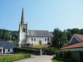 The church in Humbercourt | |
 Coat of arms | |
show Location of Humbercourt | |
 Humbercourt | |
| Coordinates: 50°12′39″N 2°27′18″E / 50.2108°N 2.455°ECoordinates: 50°12′39″N 2°27′18″E / 50.2108°N 2.455°E | |
| Country | France |
| Region | Hauts-de-France |
| Department | Somme |
| Arrondissement | Amiens |
| Canton | Doullens |
| Intercommunality | CC Territoire Nord Picardie |
| Government | |
| • Mayor (2020–2026) | Catherine Penet-Caron |
| Area 1 | 8.25 km2 (3.19 sq mi) |
| Population (Jan. 2018)[1] | 269 |
| • Density | 33/km2 (84/sq mi) |
| Time zone | UTC+01:00 (CET) |
| • Summer (DST) | UTC+02:00 (CEST) |
| INSEE/Postal code | 80445 /80600 |
| Elevation | 95–173 m (312–568 ft) (avg. 115 m or 377 ft) |
| 1 French Land Register data, which excludes lakes, ponds, glaciers > 1 km2 (0.386 sq mi or 247 acres) and river estuaries. | |


Humbercourt is a commune in the Somme department in Hauts-de-France in northern France.
Geography[]
Humbercourt is situated on the D127 road, some 16 miles (26 km) southwest of Arras and on the border with the Pas-de-Calais département formed by the valley. To the north is the Bois de Dessus, but for the most part, the district is flat farm land.
History[]
Linked with the seigneurs of the House of Brimeu, whose coats of arms adorn the church porch, along with the Toison d'Or awarded to Jean De Brimeu for his services to the duke, Charles the Bold.
Population[]
| Year | 1962 | 1968 | 1975 | 1982 | 1990 | 1999 | 2006 |
|---|---|---|---|---|---|---|---|
| Population | 352 | 370 | 327 | 303 | 295 | 279 | 260 |
| From the year 1962 on: No double counting—residents of multiple communes (e.g. students and military personnel) are counted only once. | |||||||
See also[]
References[]
- ^ "Populations légales 2018". INSEE. 28 December 2020.
| Wikimedia Commons has media related to Humbercourt. |
Categories:
- Communes of Somme (department)
- Amiens arrondissement geography stubs