Liercourt
Liercourt | |
|---|---|
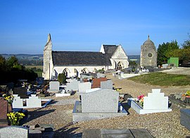 The church and cemetery in Liercourt | |
 Coat of arms | |
show Location of Liercourt | |
 Liercourt | |
| Coordinates: 50°02′24″N 1°54′03″E / 50.04°N 1.9008°ECoordinates: 50°02′24″N 1°54′03″E / 50.04°N 1.9008°E | |
| Country | France |
| Region | Hauts-de-France |
| Department | Somme |
| Arrondissement | Abbeville |
| Canton | Gamaches |
| Intercommunality | CA Baie de Somme |
| Government | |
| • Mayor (2020–2026) | Philippe Walrave[1] |
| Area 1 | 5.53 km2 (2.14 sq mi) |
| Population (Jan. 2018)[2] | 369 |
| • Density | 67/km2 (170/sq mi) |
| Time zone | UTC+01:00 (CET) |
| • Summer (DST) | UTC+02:00 (CEST) |
| INSEE/Postal code | 80476 /80580 |
| Elevation | 7–104 m (23–341 ft) (avg. 9 m or 30 ft) |
| 1 French Land Register data, which excludes lakes, ponds, glaciers > 1 km2 (0.386 sq mi or 247 acres) and river estuaries. | |


Liercourt is a commune in the Somme department in Hauts-de-France in northern France.
Geography[]
Liercourt is situated at the junction of the D3 and D901 roads, in the valley of the Somme River, 7 miles (11 km) southeast of Abbeville.
Population[]
| Year | Pop. | ±% p.a. |
|---|---|---|
| 1968 | 290 | — |
| 1975 | 289 | −0.05% |
| 1982 | 332 | +2.00% |
| 1990 | 289 | −1.72% |
| 1999 | 320 | +1.14% |
| 2007 | 355 | +1.31% |
| 2012 | 343 | −0.69% |
| 2017 | 359 | +0.92% |
| Source: INSEE[3] | ||
Places of interest[]
- The church
See also[]
References[]
- ^ "Répertoire national des élus: les maires". data.gouv.fr, Plateforme ouverte des données publiques françaises (in French). 2 December 2020.
- ^ "Populations légales 2018". INSEE. 28 December 2020.
- ^ Population en historique depuis 1968, INSEE
| Wikimedia Commons has media related to Liercourt. |
Categories:
- Communes of Somme (department)
- Ambiani
- Abbeville arrondissement geography stubs