Rivery
Rivery | |
|---|---|
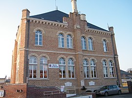 The town hall in Rivery | |
 Coat of arms | |
show Location of Rivery | |
 Rivery | |
| Coordinates: 49°54′13″N 2°19′40″E / 49.9036°N 2.3278°ECoordinates: 49°54′13″N 2°19′40″E / 49.9036°N 2.3278°E | |
| Country | France |
| Region | Hauts-de-France |
| Department | Somme |
| Arrondissement | Amiens |
| Canton | Amiens-3 |
| Intercommunality | Amiens Métropole |
| Government | |
| • Mayor (2020–2026) | Bernard Bocquillon |
| Area 1 | 6.37 km2 (2.46 sq mi) |
| Population (Jan. 2018)[1] | 3,576 |
| • Density | 560/km2 (1,500/sq mi) |
| Time zone | UTC+01:00 (CET) |
| • Summer (DST) | UTC+02:00 (CEST) |
| INSEE/Postal code | 80674 /80136 |
| Elevation | 22–76 m (72–249 ft) (avg. 25 m or 82 ft) |
| 1 French Land Register data, which excludes lakes, ponds, glaciers > 1 km2 (0.386 sq mi or 247 acres) and river estuaries. | |


Rivery is a commune in the Somme department in Hauts-de-France in northern France.
Geography[]
Rivery is situated on the north-eastern outskirts of Amiens, on the other side of the Somme River and on the D1 road. The area is known for its market gardens, or ‘hortillons’, small patches of cultivated land between the drainage channels that prevent the area returning to marsh.
Population[]
|
| ||||||||||||||||||||||||||||||||||||||||||||||||
| Source: EHESS[2] and INSEE[3] | |||||||||||||||||||||||||||||||||||||||||||||||||
See also[]
References[]
- ^ "Populations légales 2018". INSEE. 28 December 2020.
- ^ Des villages de Cassini aux communes d'aujourd'hui: Commune data sheet Rivery, EHESS. (in French)
- ^ Population en historique depuis 1968, INSEE
| Wikimedia Commons has media related to Rivery. |
Categories:
- Communes of Somme (department)
- Amiens arrondissement geography stubs