Saigneville
Saigneville | |
|---|---|
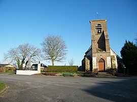 The war memorial and church in Saigneville | |
show Location of Saigneville | |
 Saigneville | |
| Coordinates: 50°08′17″N 1°42′45″E / 50.1381°N 1.7125°ECoordinates: 50°08′17″N 1°42′45″E / 50.1381°N 1.7125°E | |
| Country | France |
| Region | Hauts-de-France |
| Department | Somme |
| Arrondissement | Abbeville |
| Canton | Abbeville-2 |
| Intercommunality | CA Baie de Somme |
| Government | |
| • Mayor (2020–2026) | Jean Gorriez[1] |
| Area 1 | 12.86 km2 (4.97 sq mi) |
| Population (Jan. 2018)[2] | 373 |
| • Density | 29/km2 (75/sq mi) |
| Time zone | UTC+01:00 (CET) |
| • Summer (DST) | UTC+02:00 (CEST) |
| INSEE/Postal code | 80691 /80230 |
| Elevation | 2–59 m (6.6–193.6 ft) (avg. 30 m or 98 ft) |
| 1 French Land Register data, which excludes lakes, ponds, glaciers > 1 km2 (0.386 sq mi or 247 acres) and river estuaries. | |


Saigneville is a commune in the Somme department in Hauts-de-France in northern France.
History[]
Prior to construction of the Canal de la Somme, Saigneville stood at the southern end of a ford across the Somme estuary. Known as Blanchetaque for the white stones marking the way, the ford became the site of the Battle of Blanchetaque in 1346, during the Hundred Years' War.
Geography[]
Saigneville is situated 5 miles (8 km) northwest of Abbeville, on the D3 road, near the Somme canal.
Population[]
| Year | 1962 | 1968 | 1975 | 1982 | 1990 | 1999 | 2006 |
|---|---|---|---|---|---|---|---|
| Population | 327 | 365 | 330 | 351 | 375 | 385 | 406 |
| From the year 1962 on: No double counting—residents of multiple communes (e.g. students and military personnel) are counted only once. | |||||||
See also[]
References[]
- ^ "Répertoire national des élus: les maires". data.gouv.fr, Plateforme ouverte des données publiques françaises (in French). 2 December 2020.
- ^ "Populations légales 2018". INSEE. 28 December 2020.
| Wikimedia Commons has media related to Saigneville. |
Categories:
- Communes of Somme (department)
- Abbeville arrondissement geography stubs