Saulxures-sur-Moselotte
Saulxures-sur-Moselotte | |
|---|---|
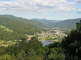 A general view of Saulxures-sur-Moselotte | |
 Coat of arms | |
show Location of Saulxures-sur-Moselotte | |
 Saulxures-sur-Moselotte | |
| Coordinates: 47°57′00″N 6°46′11″E / 47.95°N 6.7697°ECoordinates: 47°57′00″N 6°46′11″E / 47.95°N 6.7697°E | |
| Country | France |
| Region | Grand Est |
| Department | Vosges |
| Arrondissement | Saint-Dié-des-Vosges |
| Canton | La Bresse |
| Intercommunality | CC Hautes Vosges |
| Government | |
| • Mayor (2020–2026) | Hervé Vaxelaire[1] |
| Area 1 | 31.87 km2 (12.31 sq mi) |
| Population (Jan. 2018)[2] | 2,540 |
| • Density | 80/km2 (210/sq mi) |
| Time zone | UTC+01:00 (CET) |
| • Summer (DST) | UTC+02:00 (CEST) |
| INSEE/Postal code | 88447 /88290 |
| Elevation | 430–1,005 m (1,411–3,297 ft) (avg. 464 m or 1,522 ft) |
| 1 French Land Register data, which excludes lakes, ponds, glaciers > 1 km2 (0.386 sq mi or 247 acres) and river estuaries. | |


Saulxures-sur-Moselotte (German: Salzern) is a commune in the Vosges department in Grand Est in northeastern France.
It is situated between Remiremont and La Bresse, just off the D43 road, within the .
The main local industries are timber, stone- and wood-working and textiles. Leisure activities offer walking in the wooded hills and the local lake.
See also[]
References[]
- ^ "Répertoire national des élus: les maires". data.gouv.fr, Plateforme ouverte des données publiques françaises (in French). 2 December 2020. Retrieved 7 December 2020.
- ^ "Populations légales 2018". INSEE. 28 December 2020.
External links[]
| Wikimedia Commons has media related to Saulxures-sur-Moselotte. |
- Official site (in French)
This Vosges geographical article is a stub. You can help Wikipedia by . |
Categories:
- Communes of Vosges (department)
- Vosges (department) geography stubs