Sazeray
show This article may be expanded with text translated from the corresponding article in French. (April 2016) Click [show] for important translation instructions. |
Sazeray | |
|---|---|
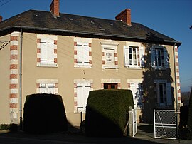 The town hall in Sazeray | |
show Location of Sazeray | |
 Sazeray | |
| Coordinates: 46°25′47″N 2°03′18″E / 46.4297°N 2.055°ECoordinates: 46°25′47″N 2°03′18″E / 46.4297°N 2.055°E | |
| Country | France |
| Region | Centre-Val de Loire |
| Department | Indre |
| Arrondissement | La Châtre |
| Canton | La Châtre |
| Government | |
| • Mayor (2020–2026) | Didier Brunet[1] |
| Area 1 | 22.69 km2 (8.76 sq mi) |
| Population (Jan. 2018)[2] | 300 |
| • Density | 13/km2 (34/sq mi) |
| Time zone | UTC+01:00 (CET) |
| • Summer (DST) | UTC+02:00 (CEST) |
| INSEE/Postal code | 36214 /36160 |
| Elevation | 260–432 m (853–1,417 ft) (avg. 438 m or 1,437 ft) |
| 1 French Land Register data, which excludes lakes, ponds, glaciers > 1 km2 (0.386 sq mi or 247 acres) and river estuaries. | |


Sazeray is a commune in the Indre department in central France, in the region of Centre-Val de Loire.
Geography[]
Location[]
The commune is situated in the southwest of the department, at the border with the département of Creuse. Nearby communes include Vigoulant, Tercillat, La Cellette, Nouziers, Pouligny Notre-Dame, and Sainte-Sévère-sur-Indre.[3]
Hamlets and lieux-dits[]
The commune's hamlets and lieux-dits are la Crie, le Grand Correix, and Villard.
Population[]
|
|
See also[]
- Communes of the Indre department
References[]
- ^ "Répertoire national des élus: les maires". data.gouv.fr, Plateforme ouverte des données publiques françaises (in French). 2 December 2020.
- ^ "Populations légales 2018". INSEE. 28 December 2020.
- ^ "Indre - Département 36 (Région Centre)". www.lion1906.com. Retrieved 2019-06-13.
| Wikimedia Commons has media related to Sazeray. |
| show Communes of the Indre department |
|---|
This Indre geographical article is a stub. You can help Wikipedia by . |
Categories:
- Communes of Indre
- Indre geography stubs