Chalais, Indre
Chalais | |
|---|---|
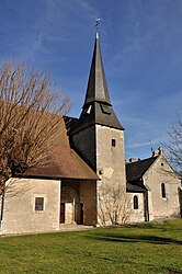 The , in Chalais | |
show Location of Chalais | |
 Chalais | |
| Coordinates: 46°32′15″N 1°11′52″E / 46.5375°N 1.1978°ECoordinates: 46°32′15″N 1°11′52″E / 46.5375°N 1.1978°E | |
| Country | France |
| Region | Centre-Val de Loire |
| Department | Indre |
| Arrondissement | Le Blanc |
| Canton | Saint-Gaultier |
| Government | |
| • Mayor (2020–2026) | Frédérique Vrignat |
| Area 1 | 39.65 km2 (15.31 sq mi) |
| Population (Jan. 2018)[1] | 144 |
| • Density | 3.6/km2 (9.4/sq mi) |
| Time zone | UTC+01:00 (CET) |
| • Summer (DST) | UTC+02:00 (CEST) |
| INSEE/Postal code | 36036 /36370 |
| Elevation | 95–161 m (312–528 ft) (avg. 144 m or 472 ft) |
| 1 French Land Register data, which excludes lakes, ponds, glaciers > 1 km2 (0.386 sq mi or 247 acres) and river estuaries. | |


Chalais (French pronunciation: [ʃalɛ]) is a commune in the Indre department in central France.
Geography[]
The commune is located in the parc naturel régional de la Brenne.
The river Anglin flows northwest through the southwestern part of the commune.
Population[]
|
|
See also[]
- Communes of the Indre department
References[]
- ^ "Populations légales 2018". INSEE. 28 December 2020.
| Wikimedia Commons has media related to Chalais (Indre). |
| show Communes of the Indre department |
|---|
This Indre geographical article is a stub. You can help Wikipedia by . |
Categories:
- Communes of Indre
- Indre geography stubs