Sougé, Indre
Sougé | |
|---|---|
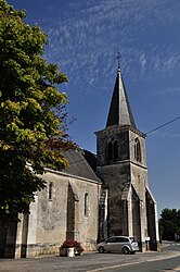 The church of Saint-Hilaire, in Sougé | |
show Location of Sougé | |
 Sougé | |
| Coordinates: 46°57′50″N 1°29′18″E / 46.9639°N 1.4883°ECoordinates: 46°57′50″N 1°29′18″E / 46.9639°N 1.4883°E | |
| Country | France |
| Region | Centre-Val de Loire |
| Department | Indre |
| Arrondissement | Châteauroux |
| Canton | Buzançais |
| Intercommunality | Val de l'Indre-Brenne |
| Government | |
| • Mayor (2020–2026) | Dominique Perrot[1] |
| Area 1 | 13.02 km2 (5.03 sq mi) |
| Population (Jan. 2018)[2] | 144 |
| • Density | 11/km2 (29/sq mi) |
| Time zone | UTC+01:00 (CET) |
| • Summer (DST) | UTC+02:00 (CEST) |
| INSEE/Postal code | 36218 /36500 |
| Elevation | 120–170 m (390–560 ft) (avg. 135 m or 443 ft) |
| 1 French Land Register data, which excludes lakes, ponds, glaciers > 1 km2 (0.386 sq mi or 247 acres) and river estuaries. | |


Sougé (French pronunciation: [suʒe]) is a commune in the Indre department, central France.
Population[]
|
|
See also[]
- Communes of the Indre department
References[]
- ^ "Répertoire national des élus: les maires". data.gouv.fr, Plateforme ouverte des données publiques françaises (in French). 2 December 2020.
- ^ "Populations légales 2018". INSEE. 28 December 2020.
| Wikimedia Commons has media related to Sougé (Indre). |
| show Communes of the Indre department |
|---|
This Indre geographical article is a stub. You can help Wikipedia by . |
Categories:
- Communes of Indre
- Indre geography stubs