Villegouin
Villegouin | |
|---|---|
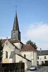 The church of Our Lady, in Villegouin | |
show Location of Villegouin | |
 Villegouin | |
| Coordinates: 46°57′54″N 1°22′26″E / 46.965°N 1.3739°ECoordinates: 46°57′54″N 1°22′26″E / 46.965°N 1.3739°E | |
| Country | France |
| Region | Centre-Val de Loire |
| Department | Indre |
| Arrondissement | Châteauroux |
| Canton | Valençay |
| Intercommunality | Écueillé-Valençay |
| Government | |
| • Mayor (2020–2026) | Michel Brunet |
| Area 1 | 24.03 km2 (9.28 sq mi) |
| Population (Jan. 2018)[1] | 325 |
| • Density | 14/km2 (35/sq mi) |
| Time zone | UTC+01:00 (CET) |
| • Summer (DST) | UTC+02:00 (CEST) |
| INSEE/Postal code | 36243 /36500 |
| Elevation | 101–201 m (331–659 ft) (avg. 125 m or 410 ft) |
| 1 French Land Register data, which excludes lakes, ponds, glaciers > 1 km2 (0.386 sq mi or 247 acres) and river estuaries. | |


Villegouin (French pronunciation: [vil.ɡwɛ̃]) is a commune in the Indre department in central France.
Geography[]
The Indrois has its source in the commune.
Population[]
|
|
See also[]
- Communes of the Indre department
References[]
- ^ "Populations légales 2018". INSEE. 28 December 2020.
| Wikimedia Commons has media related to Villegouin. |
| show Communes of the Indre department |
|---|
This Indre geographical article is a stub. You can help Wikipedia by . |
Categories:
- Communes of Indre
- Indre geography stubs