Le Menoux
Le Menoux | |
|---|---|
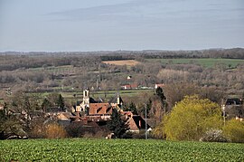 A general view of Le Menoux | |
show Location of Le Menoux | |
 Le Menoux | |
| Coordinates: 46°33′19″N 1°34′14″E / 46.5553°N 1.5706°ECoordinates: 46°33′19″N 1°34′14″E / 46.5553°N 1.5706°E | |
| Country | France |
| Region | Centre-Val de Loire |
| Department | Indre |
| Arrondissement | Châteauroux |
| Canton | Argenton-sur-Creuse |
| Government | |
| • Mayor (2020–2026) | Chantal Larue-Ricot |
| Area 1 | 5.58 km2 (2.15 sq mi) |
| Population (Jan. 2018)[1] | 431 |
| • Density | 77/km2 (200/sq mi) |
| Time zone | UTC+01:00 (CET) |
| • Summer (DST) | UTC+02:00 (CEST) |
| INSEE/Postal code | 36117 /36200 |
| Elevation | 108–267 m (354–876 ft) (avg. 160 m or 520 ft) |
| 1 French Land Register data, which excludes lakes, ponds, glaciers > 1 km2 (0.386 sq mi or 247 acres) and river estuaries. | |


Le Menoux is a commune in the Indre department in central France.
Population[]
|
|
See also[]
- Communes of the Indre department
References[]
- ^ "Populations légales 2018". INSEE. 28 December 2020.
| Wikimedia Commons has media related to Le Menoux. |
| show Communes of the Indre department |
|---|
This Indre geographical article is a stub. You can help Wikipedia by . |
Categories:
- Communes of Indre
- Indre geography stubs