Fougerolles, Indre
Fougerolles | |
|---|---|
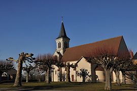 The church of Saint-Pierre, in Fougerolles | |
show Location of Fougerolles | |
 Fougerolles | |
| Coordinates: 46°33′50″N 1°52′02″E / 46.5639°N 1.8672°ECoordinates: 46°33′50″N 1°52′02″E / 46.5639°N 1.8672°E | |
| Country | France |
| Region | Centre-Val de Loire |
| Department | Indre |
| Arrondissement | La Châtre |
| Canton | Neuvy-Saint-Sépulchre |
| Government | |
| • Mayor (2008–2014) | Marie-Jeanne Lafarcinade |
| Area 1 | 17.17 km2 (6.63 sq mi) |
| Population (Jan. 2018)[1] | 353 |
| • Density | 21/km2 (53/sq mi) |
| Time zone | UTC+01:00 (CET) |
| • Summer (DST) | UTC+02:00 (CEST) |
| INSEE/Postal code | 36078 /36230 |
| Elevation | 187–284 m (614–932 ft) (avg. 250 m or 820 ft) |
| 1 French Land Register data, which excludes lakes, ponds, glaciers > 1 km2 (0.386 sq mi or 247 acres) and river estuaries. | |


Fougerolles is a commune in the Indre department in central France.
Population[]
|
|
See also[]
- Communes of the Indre department
References[]
- ^ "Populations légales 2018". INSEE. 28 December 2020.
| Wikimedia Commons has media related to Fougerolles (Indre). |
| show Communes of the Indre department |
|---|
| show Authority control |
|---|
This Indre geographical article is a stub. You can help Wikipedia by . |
Categories:
- Communes of Indre
- Indre geography stubs