Uzemain
show This article may be expanded with text translated from the corresponding article in French. (December 2015) Click [show] for important translation instructions. |
Uzemain | |
|---|---|
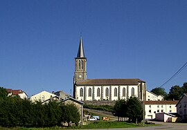 Sainte-Madeleine | |
show Location of Uzemain | |
 Uzemain | |
| Coordinates: 48°05′11″N 6°20′44″E / 48.0864°N 6.3456°ECoordinates: 48°05′11″N 6°20′44″E / 48.0864°N 6.3456°E | |
| Country | France |
| Region | Grand Est |
| Department | Vosges |
| Arrondissement | Épinal |
| Canton | Le Val-d'Ajol |
| Intercommunality | CA Épinal |
| Government | |
| • Mayor (2008–2014) | Alain Pierre |
| Area 1 | 27.3 km2 (10.5 sq mi) |
| Population (Jan. 2018)[1] | 1,046 |
| • Density | 38/km2 (99/sq mi) |
| Time zone | UTC+01:00 (CET) |
| • Summer (DST) | UTC+02:00 (CEST) |
| INSEE/Postal code | 88484 /88220 |
| Elevation | 305–467 m (1,001–1,532 ft) (avg. 317 m or 1,040 ft) |
| Website | www.uzemain.fr |
| 1 French Land Register data, which excludes lakes, ponds, glaciers > 1 km2 (0.386 sq mi or 247 acres) and river estuaries. | |


Uzemain is a commune in the Vosges department in Grand Est in northeastern France.
Geography[]
The Côney forms part of the commune's eastern border, flows westward through the southern part of the commune, crosses the village, and forms part of the commune's southwestern border.
See also[]
References[]
- ^ "Populations légales 2018". INSEE. 28 December 2020.
External links[]
| Wikimedia Commons has media related to Uzemain. |
This Vosges geographical article is a stub. You can help Wikipedia by . |
Categories:
- Communes of Vosges (department)
- Vosges (department) geography stubs