Vadencourt, Somme
Vadencourt | |
|---|---|
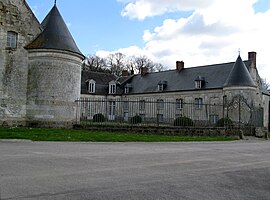 Chateau of Vadencourt | |
show Location of Vadencourt | |
 Vadencourt | |
| Coordinates: 50°00′28″N 2°29′25″E / 50.0078°N 2.4903°ECoordinates: 50°00′28″N 2°29′25″E / 50.0078°N 2.4903°E | |
| Country | France |
| Region | Hauts-de-France |
| Department | Somme |
| Arrondissement | Amiens |
| Canton | Corbie |
| Intercommunality | CC Territoire Nord Picardie |
| Government | |
| • Mayor (2020–2026) | Christian Bocquet[1] |
| Area 1 | 4.92 km2 (1.90 sq mi) |
| Population (Jan. 2018)[2] | 103 |
| • Density | 21/km2 (54/sq mi) |
| Time zone | UTC+01:00 (CET) |
| • Summer (DST) | UTC+02:00 (CEST) |
| INSEE/Postal code | 80773 /80560 |
| Elevation | 53–120 m (174–394 ft) (avg. 65 m or 213 ft) |
| 1 French Land Register data, which excludes lakes, ponds, glaciers > 1 km2 (0.386 sq mi or 247 acres) and river estuaries. | |


Vadencourt (French pronunciation: [vadɑ̃kuʁ]) is a commune in the Somme department in Hauts-de-France in northern France.
Geography[]
Vadencourt is situated 10 miles (16 km) northeast of Amiens, on the D919 road
Population[]
| Year | 1962 | 1968 | 1975 | 1982 | 1990 | 1999 | 2006 |
|---|---|---|---|---|---|---|---|
| Population | 79 | 80 | 73 | 74 | 93 | 104 | 104 |
| From the year 1962 on: No double counting—residents of multiple communes (e.g. students and military personnel) are counted only once. | |||||||
Places of interest[]
- Château : Both wings of the building are flanked with a round tower emphasizing the impression of fortification, while allowing controlled access to the semicircular inner courtyard. The good state of repair of the roof contrasts with the state of neglect observed in the courtyard, whose cobblestones are beginning to be invaded by high grass.
- The church
See also[]
References[]
- ^ "Répertoire national des élus: les maires". data.gouv.fr, Plateforme ouverte des données publiques françaises (in French). 2 December 2020.
- ^ "Populations légales 2018". INSEE. 28 December 2020.
| Wikimedia Commons has media related to Vadencourt (Somme). |
Categories:
- Communes of Somme (department)
- Amiens arrondissement geography stubs