Woignarue
From Wikipedia, the free encyclopedia
Commune in Hauts-de-France, France
Woignarue | |
|---|---|
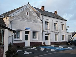 The town hall in Woignarue | |
 Coat of arms | |
 Woignarue  Woignarue | |
Coordinates:  50°06′38″N 1°29′46″E / 50.1106°N 1.4961°E / 50.1106; 1.4961Coordinates: 50°06′38″N 1°29′46″E / 50.1106°N 1.4961°E / 50.1106; 1.4961 50°06′38″N 1°29′46″E / 50.1106°N 1.4961°E / 50.1106; 1.4961Coordinates: 50°06′38″N 1°29′46″E / 50.1106°N 1.4961°E / 50.1106; 1.4961 | |
| Country | France |
| Region | Hauts-de-France |
| Department | Somme |
| Arrondissement | Abbeville |
| Canton | Friville-Escarbotin |
| Intercommunality | Villes Sœurs |
| Government | |
| • Mayor (2020–2026) | Dominique Mallet |
| Area 1 | 16.51 km2 (6.37 sq mi) |
| Population (Jan. 2018)[1] | 797 |
| • Density | 48/km2 (130/sq mi) |
| Time zone | UTC+01:00 (CET) |
| • Summer (DST) | UTC+02:00 (CEST) |
| INSEE/Postal code | 80826 /80460 |
| Elevation | 0–87 m (0–285 ft) (avg. 60 m or 200 ft) |
| 1 French Land Register data, which excludes lakes, ponds, glaciers > 1 km2 (0.386 sq mi or 247 acres) and river estuaries. | |

Woignarue is a commune in the Somme department in Hauts-de-France in northern France.
Geography[]
Woignarue is situated 15 miles(24 km) west of Abbeville, on the D463 road
Population[]
| Year | Pop. | ±% |
|---|---|---|
| 2006 | 793 | — |
| 2007 | 802 | +1.1% |
| 2008 | 810 | +1.0% |
| 2009 | 817 | +0.9% |
| 2010 | 822 | +0.6% |
| 2011 | 830 | +1.0% |
| 2012 | 837 | +0.8% |
| 2013 | 845 | +1.0% |
| 2014 | 853 | +0.9% |
| 2015 | 854 | +0.1% |
| 2016 | 835 | −2.2% |
See also[]
References[]
- ^ "Populations légales 2018". INSEE. 28 December 2020.
External links[]
| Wikimedia Commons has media related to Woignarue. |
- Local area website (in French)
show
Communes of the Somme department | |
|---|---|
|
| show Authority control | |
|---|---|
| General | |
| National libraries | |
This Arrondissement of Abbeville geographical article is a stub. You can help Wikipedia by . |
- v
- t
Retrieved from ""
Categories:
- Communes of Somme (department)
- Abbeville arrondissement geography stubs
Hidden categories:
- Articles with short description
- Short description is different from Wikidata
- Infobox mapframe without OSM relation ID on Wikidata
- Coordinates on Wikidata
- Pages using infobox settlement with image map1 but not image map
- Commons category link from Wikidata
- Articles with French-language sources (fr)
- Articles with GND identifiers
- Articles with VIAF identifiers
- Articles with BNF identifiers
- Articles with LCCN identifiers
- Articles with WorldCat-VIAF identifiers
- All stub articles
- Pages using the Kartographer extension