Bartherans
Bartherans | |
|---|---|
 The church in Bartherans | |
show Location of Bartherans | |
 Bartherans | |
| Coordinates: 47°02′33″N 5°55′46″E / 47.0425°N 5.9294°ECoordinates: 47°02′33″N 5°55′46″E / 47.0425°N 5.9294°E | |
| Country | France |
| Region | Bourgogne-Franche-Comté |
| Department | Doubs |
| Arrondissement | Besançon |
| Canton | Saint-Vit |
| Intercommunality | Loue-Lison |
| Government | |
| • Mayor (2008–2014) | Jean Salvi |
| Area 1 | 5.81 km2 (2.24 sq mi) |
| Population (Jan. 2018)[1] | 57 |
| • Density | 9.8/km2 (25/sq mi) |
| Time zone | UTC+01:00 (CET) |
| • Summer (DST) | UTC+02:00 (CEST) |
| INSEE/Postal code | 25044 /25440 |
| Elevation | 408–570 m (1,339–1,870 ft) |
| 1 French Land Register data, which excludes lakes, ponds, glaciers > 1 km2 (0.386 sq mi or 247 acres) and river estuaries. | |


Bartherans is a commune in the Doubs department in the Bourgogne-Franche-Comté region in eastern France.
Geography[]
Bartherans is situated at 455 m of altitude approximately 23 km southwest of Besançon in a wooded valley.
Neighbouring communities are Montfort in the north, Échay and Myon in the east, Ivrey in the south, and Ronchaux in the west.
History[]
Gaspard Grandjean from the village founded a chapel devoted to Saint-Antoine and Hubert in 1586. The ruins of the crypt can still be seen in the cemetery.
Population[]
| Year | Pop. | ±% |
|---|---|---|
| 1962 | 68 | — |
| 1968 | 61 | −10.3% |
| 1975 | 41 | −32.8% |
| 1982 | 50 | +22.0% |
| 1990 | 46 | −8.0% |
| 1999 | 52 | +13.0% |
| 2008 | 47 | −9.6% |
| 2012 | 48 | +2.1% |
Sights[]
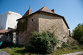
There is a seventeenth-century manor house Mouret de Châtillon which is called le château, although it is not as grand as that name implies.
The 19th-century church boasts a bronze bell.
See also[]
References[]
- ^ "Populations légales 2018". INSEE. 28 December 2020.
| Wikimedia Commons has media related to Bartherans. |
This Doubs geographical article is a stub. You can help Wikipedia by . |
- Communes of Doubs
- Doubs geography stubs