Bonneval, Eure-et-Loir
Bonneval | |
|---|---|
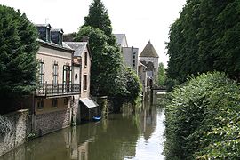 A general view of Bonneval | |
 Coat of arms | |
show Location of Bonneval | |
 Bonneval | |
| Coordinates: 48°10′56″N 1°23′20″E / 48.1822°N 1.3889°ECoordinates: 48°10′56″N 1°23′20″E / 48.1822°N 1.3889°E | |
| Country | France |
| Region | Centre-Val de Loire |
| Department | Eure-et-Loir |
| Arrondissement | Châteaudun |
| Canton | Châteaudun |
| Intercommunality | Bonnevalais |
| Government | |
| • Mayor (2020–2026) | Joël Billard[1] |
| Area 1 | 28.82 km2 (11.13 sq mi) |
| Population (Jan. 2018)[2] | 4,950 |
| • Density | 170/km2 (440/sq mi) |
| Time zone | UTC+01:00 (CET) |
| • Summer (DST) | UTC+02:00 (CEST) |
| INSEE/Postal code | 28051 /28800 |
| Elevation | 112–175 m (367–574 ft) (avg. 132 m or 433 ft) |
| 1 French Land Register data, which excludes lakes, ponds, glaciers > 1 km2 (0.386 sq mi or 247 acres) and river estuaries. | |


Bonneval (French pronunciation: [bɔnval]) is a commune in the Eure-et-Loir department in northern France.
Population[]
|
|
See also[]
- Communes of the Eure-et-Loir department
References[]
- ^ "Répertoire national des élus: les maires". data.gouv.fr, Plateforme ouverte des données publiques françaises (in French). 2 December 2020.
- ^ "Populations légales 2018". INSEE. 28 December 2020.
| Wikimedia Commons has media related to Bonneval (Eure-et-Loir). |
| show Communes of the Eure-et-Loir department of France |
|---|
This Eure-et-Loir geographical article is a stub. You can help Wikipedia by . |
Categories:
- Communes of Eure-et-Loir
- Orléanais
- Eure-et-Loir geography stubs