La Chapelle-d'Aunainville
show This article may be expanded with text translated from the corresponding article in French. (June 2015) Click [show] for important translation instructions. |
La Chapelle-d'Aunainville | |
|---|---|
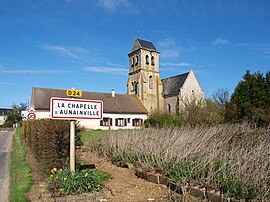 The church in La Chapelle-d'Aunainville | |
show Location of La Chapelle-d'Aunainville | |
 La Chapelle-d'Aunainville | |
| Coordinates: 48°25′30″N 1°48′54″E / 48.425°N 1.815°ECoordinates: 48°25′30″N 1°48′54″E / 48.425°N 1.815°E | |
| Country | France |
| Region | Centre-Val de Loire |
| Department | Eure-et-Loir |
| Arrondissement | Chartres |
| Canton | Auneau |
| Government | |
| • Mayor (2008–2014) | Joël Marchand |
| Area 1 | 7.5 km2 (2.9 sq mi) |
| Population (Jan. 2018)[1] | 265 |
| • Density | 35/km2 (92/sq mi) |
| Time zone | UTC+01:00 (CET) |
| • Summer (DST) | UTC+02:00 (CEST) |
| INSEE/Postal code | 28074 /28700 |
| Elevation | 138–156 m (453–512 ft) (avg. 152 m or 499 ft) |
| 1 French Land Register data, which excludes lakes, ponds, glaciers > 1 km2 (0.386 sq mi or 247 acres) and river estuaries. | |


La Chapelle-d'Aunainville is a commune in the Eure-et-Loir department in northern France.
Population[]
| Year | Pop. | ±% |
|---|---|---|
| 1962 | 118 | — |
| 1968 | 146 | +23.7% |
| 1975 | 120 | −17.8% |
| 1982 | 144 | +20.0% |
| 1990 | 188 | +30.6% |
| 1999 | 263 | +39.9% |
| 2008 | 263 | +0.0% |
See also[]
- Communes of the Eure-et-Loir department
References[]
- ^ "Populations légales 2018". INSEE. 28 December 2020.
| Wikimedia Commons has media related to La Chapelle-d'Aunainville. |
| show Communes of the Eure-et-Loir department of France |
|---|
This Eure-et-Loir geographical article is a stub. You can help Wikipedia by . |
Categories:
- Communes of Eure-et-Loir
- Eure-et-Loir geography stubs