Faget-Abbatial
Faget-Abbatial | |
|---|---|
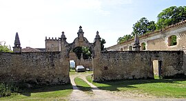 Entrance to the abbatial palace | |
 Coat of arms | |
show Location of Faget-Abbatial | |
 Faget-Abbatial | |
| Coordinates: 43°30′25″N 0°41′41″E / 43.5069°N 0.6947°ECoordinates: 43°30′25″N 0°41′41″E / 43.5069°N 0.6947°E | |
| Country | France |
| Region | Occitanie |
| Department | Gers |
| Arrondissement | Mirande |
| Canton | Astarac-Gimone |
| Intercommunality | |
| Government | |
| • Mayor (2020–2026) | Daniel Dumont |
| Area 1 | 17.46 km2 (6.74 sq mi) |
| Population (Jan. 2018)[1] | 217 |
| • Density | 12/km2 (32/sq mi) |
| Time zone | UTC+01:00 (CET) |
| • Summer (DST) | UTC+02:00 (CEST) |
| INSEE/Postal code | 32130 /32450 |
| Elevation | 182–303 m (597–994 ft) (avg. 215 m or 705 ft) |
| 1 French Land Register data, which excludes lakes, ponds, glaciers > 1 km2 (0.386 sq mi or 247 acres) and river estuaries. | |


Faget-Abbatial (French pronunciation: [faʒɛ abatjal]; Occitan: Faget Abadiau) is a commune in the Gers department in southwestern France.
Geography[]

Faget-Abbatial and its surrounding communes
Population[]
| Year | Pop. | ±% |
|---|---|---|
| 2004 | 224 | — |
| 2006 | 228 | +1.8% |
| 2007 | 228 | +0.0% |
| 2008 | 229 | +0.4% |
| 2009 | 229 | +0.0% |
| 2010 | 228 | −0.4% |
| 2011 | 228 | +0.0% |
| 2012 | 227 | −0.4% |
| 2013 | 225 | −0.9% |
| 2014 | 223 | −0.9% |
| 2015 | 221 | −0.9% |
| 2016 | 218 | −1.4% |
See also[]
- Communes of the Gers department
References[]
- ^ "Populations légales 2018". INSEE. 28 December 2020.
| Wikimedia Commons has media related to Faget-Abbatial. |
| show Communes of the Gers department |
|---|
This Gers geographical article is a stub. You can help Wikipedia by . |
Categories:
- Communes of Gers
- Gers geography stubs