Flamarens
Flamarens | |
|---|---|
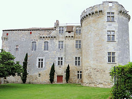 Chateau | |
show Location of Flamarens | |
 Flamarens | |
| Coordinates: 44°01′05″N 0°47′37″E / 44.0181°N 0.7936°ECoordinates: 44°01′05″N 0°47′37″E / 44.0181°N 0.7936°E | |
| Country | France |
| Region | Occitanie |
| Department | Gers |
| Arrondissement | Condom |
| Canton | Lectoure-Lomagne |
| Intercommunality | Lomagne Gersoise |
| Government | |
| • Mayor (2008–2014) | Xavier Ballenghien |
| Area 1 | 14.36 km2 (5.54 sq mi) |
| Population (Jan. 2018)[1] | 153 |
| • Density | 11/km2 (28/sq mi) |
| Time zone | UTC+01:00 (CET) |
| • Summer (DST) | UTC+02:00 (CEST) |
| INSEE/Postal code | 32131 /32340 |
| Elevation | 77–212 m (253–696 ft) |
| 1 French Land Register data, which excludes lakes, ponds, glaciers > 1 km2 (0.386 sq mi or 247 acres) and river estuaries. | |


Flamarens is a commune in the Gers department in southwestern France.
Geography[]
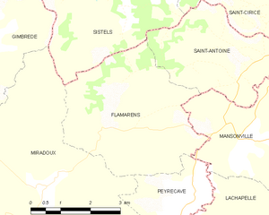
Flamarens and its surrounding communes
Population[]
| Year | Pop. | ±% |
|---|---|---|
| 1962 | 227 | — |
| 1968 | 189 | −16.7% |
| 1975 | 164 | −13.2% |
| 1982 | 168 | +2.4% |
| 1990 | 145 | −13.7% |
| 1999 | 146 | +0.7% |
| 2008 | 117 | −19.9% |
See also[]
- Communes of the Gers department
References[]
- ^ "Populations légales 2018". INSEE. 28 December 2020.
| Wikimedia Commons has media related to Flamarens. |
| show Communes of the Gers department |
|---|
| show Authority control |
|---|
This Gers geographical article is a stub. You can help Wikipedia by . |
Categories:
- Communes of Gers
- Gers geography stubs