Lachapelle, Somme
Lachapelle | |
|---|---|
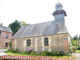 The church in Lachapelle | |
show Location of Lachapelle | |
 Lachapelle | |
| Coordinates: 49°45′57″N 1°57′29″E / 49.7658°N 1.9581°ECoordinates: 49°45′57″N 1°57′29″E / 49.7658°N 1.9581°E | |
| Country | France |
| Region | Hauts-de-France |
| Department | Somme |
| Arrondissement | Amiens |
| Canton | Poix-de-Picardie |
| Intercommunality | CC Somme Sud-Ouest |
| Government | |
| • Mayor (2020–2026) | Jérémie Morard[1] |
| Area 1 | 2.51 km2 (0.97 sq mi) |
| Population (Jan. 2018)[2] | 88 |
| • Density | 35/km2 (91/sq mi) |
| Time zone | UTC+01:00 (CET) |
| • Summer (DST) | UTC+02:00 (CEST) |
| INSEE/Postal code | 80455 /80290 |
| Elevation | 109–183 m (358–600 ft) (avg. 1,180 m or 3,870 ft) |
| 1 French Land Register data, which excludes lakes, ponds, glaciers > 1 km2 (0.386 sq mi or 247 acres) and river estuaries. | |


Lachapelle (French pronunciation: [laʃapɛl]) is a commune in the Somme department in Hauts-de-France in northern France.
Geography[]
Lachapelle lies on the banks of the river Poix, at the junction of the D919 and D266 roads, some 20 miles (32 km) southwest of Amiens.
Population[]
| Year | 1962 | 1968 | 1975 | 1982 | 1990 | 1999 | 2006 |
|---|---|---|---|---|---|---|---|
| Population | 42 | 47 | 53 | 48 | 42 | 51 | 65 |
| From the year 1962 on: No double counting—residents of multiple communes (e.g. students and military personnel) are counted only once. | |||||||
See also[]
References[]
- ^ "Répertoire national des élus: les maires". data.gouv.fr, Plateforme ouverte des données publiques françaises (in French). 2 December 2020.
- ^ "Populations légales 2018". INSEE. 28 December 2020.
| Wikimedia Commons has media related to Lachapelle (Somme). |
Categories:
- Communes of Somme (department)
- Amiens arrondissement geography stubs