Louslitges
Louslitges | |
|---|---|
 The town hall in Louslitges | |
show Location of Louslitges | |
 Louslitges | |
| Coordinates: 43°35′46″N 0°09′55″E / 43.5961°N 0.1653°ECoordinates: 43°35′46″N 0°09′55″E / 43.5961°N 0.1653°E | |
| Country | France |
| Region | Occitanie |
| Department | Gers |
| Arrondissement | Mirande |
| Canton | Pardiac-Rivière-Basse |
| Government | |
| • Mayor (2020–2026) | Jean-Luc Drussel |
| Area 1 | 12.03 km2 (4.64 sq mi) |
| Population (Jan. 2018)[1] | 64 |
| • Density | 5.3/km2 (14/sq mi) |
| Time zone | UTC+01:00 (CET) |
| • Summer (DST) | UTC+02:00 (CEST) |
| INSEE/Postal code | 32217 /32230 |
| Elevation | 145–270 m (476–886 ft) (avg. 200 m or 660 ft) |
| 1 French Land Register data, which excludes lakes, ponds, glaciers > 1 km2 (0.386 sq mi or 247 acres) and river estuaries. | |


Louslitges (French pronunciation: [luslitʒ]; Occitan: Los Litges) is a commune in the Gers department in southwestern France.
Geography[]
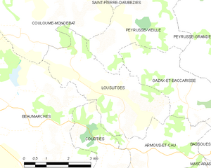
Louslitges and its surrounding communes
Population[]
| Year | Pop. | ±% |
|---|---|---|
| 1962 | 145 | — |
| 1968 | 129 | −11.0% |
| 1975 | 97 | −24.8% |
| 1982 | 83 | −14.4% |
| 1990 | 87 | +4.8% |
| 1999 | 84 | −3.4% |
| 2008 | 80 | −4.8% |
Transportation[]
There are four airports close to Louslitges: Lourdes (47 km), Pau (53 km), Toulouse (96 km), and Biarritz (137 km).
See also[]
- Communes of the Gers department
References[]
- ^ "Populations légales 2018". INSEE. 28 December 2020.
| Wikimedia Commons has media related to Louslitges. |
| show Communes of the Gers department |
|---|
This Gers geographical article is a stub. You can help Wikipedia by . |
Categories:
- Communes of Gers
- Gers geography stubs