Plieux
Plieux | |
|---|---|
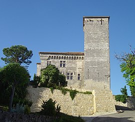 Château de Plieux | |
show Location of Plieux | |
 Plieux | |
| Coordinates: 43°57′05″N 0°44′05″E / 43.9514°N 0.7347°ECoordinates: 43°57′05″N 0°44′05��E / 43.9514°N 0.7347°E | |
| Country | France |
| Region | Occitanie |
| Department | Gers |
| Arrondissement | Condom |
| Canton | Lectoure-Lomagne |
| Government | |
| • Mayor (2020–2026) | Maryse Claverie |
| Area 1 | 12.27 km2 (4.74 sq mi) |
| Population (Jan. 2018)[1] | 142 |
| • Density | 12/km2 (30/sq mi) |
| Time zone | UTC+01:00 (CET) |
| • Summer (DST) | UTC+02:00 (CEST) |
| INSEE/Postal code | 32320 /32340 |
| Elevation | 82–187 m (269–614 ft) (avg. 187 m or 614 ft) |
| 1 French Land Register data, which excludes lakes, ponds, glaciers > 1 km2 (0.386 sq mi or 247 acres) and river estuaries. | |


Plieux (French pronunciation: [plijø]; Occitan: Plius) is a commune in the Gers department in southwestern France.
Geography[]
Locality[]

Plieux and its surrounding communes
Hydrography[]
The Auroue flows north through the western part of the commune; the river Arrats forms all of the commune's eastern border.
Population[]
| Year | Pop. | ±% |
|---|---|---|
| 1962 | 245 | — |
| 1968 | 232 | −5.3% |
| 1975 | 214 | −7.8% |
| 1982 | 195 | −8.9% |
| 1990 | 186 | −4.6% |
| 1999 | 174 | −6.5% |
| 2008 | 161 | −7.5% |

See also[]
- Communes of the Gers department
References[]
- ^ "Populations légales 2018". INSEE. 28 December 2020.
| Wikimedia Commons has media related to Plieux. |
| show Communes of the Gers department |
|---|
| show Authority control |
|---|
This Gers geographical article is a stub. You can help Wikipedia by . |
Categories:
- Communes of Gers
- Gers geography stubs