Saint-Clar
show This article may be expanded with text translated from the corresponding article in French. (February 2012) Click [show] for important translation instructions. |
Saint-Clar | |
|---|---|
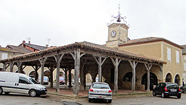 Covered market and town hall | |
 Coat of arms | |
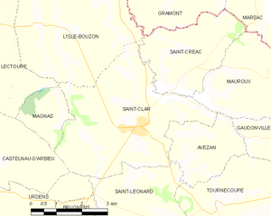
show Location of Saint-Clar | |
 Saint-Clar | |
| Coordinates: 43°53′34″N 0°46′15″E / 43.8928°N 0.7708°ECoordinates: 43°53′34″N 0°46′15″E / 43.8928°N 0.7708°E | |
| Country | France |
| Region | Occitanie |
| Department | Gers |
| Arrondissement | Condom |
| Canton | Fleurance-Lomagne |
| Government | |
| • Mayor (2020–2026) | David Taupiac[1] |
| Area 1 | 17.91 km2 (6.92 sq mi) |
| Population (Jan. 2018)[2] | 1,031 |
| • Density | 58/km2 (150/sq mi) |
| Time zone | UTC+01:00 (CET) |
| • Summer (DST) | UTC+02:00 (CEST) |
| INSEE/Postal code | 32370 /32380 |
| Elevation | 93–193 m (305–633 ft) (avg. 160 m or 520 ft) |
| 1 French Land Register data, which excludes lakes, ponds, glaciers > 1 km2 (0.386 sq mi or 247 acres) and river estuaries. | |


Saint-Clar (French pronunciation: [sɛ̃ klaʁ]; Occitan: Sent Clar) is a commune in the Gers department in southwestern France.
Geography[]
The river Arrats forms most of the commune's eastern border; the Auroue flows north through the western part of the commune.
History[]
Saint-Clar was founded in 1289 by Edward I, King of England and Duke of Aquitaine.
Structure[]
Its grid layout follows the standards of the typical Bastides grid. The basic architectural element is the central square boarded by arcades and stone and half-timbered houses. This square was the market place and the center of the communities’ economy.[3] The market hall (market building) in the central square was built with stone and with wooden pillars. Now it hosts the Town Hall (Place de la Mairie), which has a beautiful steeple with clock. This Town Hall was better known as “maison commune”.[4] Apart from that central square, Saint-Clar has one more arcaded square, both just a few steps away from each other. This is located in the south, in the original village, in the “castet bielh” (old quarter).
Population[5][]
| Year | Pop. | ±% |
|---|---|---|
| 1962 | 1,030 | — |
| 1968 | 1,033 | +0.3% |
| 1975 | 987 | −4.5% |
| 1982 | 972 | −1.5% |
| 1990 | 879 | −9.6% |
| 1999 | 868 | −1.3% |
| 2008 | 980 | +12.9% |
See also[]
| Wikimedia Commons has media related to Saint-Clar. |
- Communes of the Gers department
References[]
- ^ "Répertoire national des élus: les maires". data.gouv.fr, Plateforme ouverte des données publiques françaises (in French). 2 December 2020.
- ^ "Populations légales 2018". INSEE. 28 December 2020.
- ^ "An Introduction to Bastides (PPT), at About The Bastides". John Reps Collection. Cornell University Library. Retrieved 14 June 2016.
- ^ "visit saint-clar gers - Site Officiel de l'Office de Tourisme Coeur de Lomagne (Saint-Clar et sa région)". www.tourisme-coeurdelomagne.com. Retrieved 20 June 2016.
- ^ "INSEE - National Institute of Statistics and Economic Studies - France". www.insee.fr. Missing or empty
|url=(help)
| show Communes of the Gers department |
|---|
| show Authority control |
|---|
This Gers geographical article is a stub. You can help Wikipedia by . |
- Communes of Gers
- Gers geography stubs