Sauviac, Gers
Sauviac | |
|---|---|
show Location of Sauviac | |
 Sauviac | |
| Coordinates: 43°24′21″N 0°27′15″E / 43.4058°N 0.4542°ECoordinates: 43°24′21″N 0°27′15″E / 43.4058°N 0.4542°E | |
| Country | France |
| Region | Occitanie |
| Department | Gers |
| Arrondissement | Mirande |
| Canton | Mirande-Astarac |
| Government | |
| • Mayor (2020–2026) | Patrick Ducombs[1] |
| Area 1 | 6.48 km2 (2.50 sq mi) |
| Population (Jan. 2018)[2] | 108 |
| • Density | 17/km2 (43/sq mi) |
| Time zone | UTC+01:00 (CET) |
| • Summer (DST) | UTC+02:00 (CEST) |
| INSEE/Postal code | 32419 /32300 |
| Elevation | 184–282 m (604–925 ft) (avg. 270 m or 890 ft) |
| 1 French Land Register data, which excludes lakes, ponds, glaciers > 1 km2 (0.386 sq mi or 247 acres) and river estuaries. | |


Sauviac (French pronunciation: [sovjak]) is a commune in the Gers department in southwestern France.
Geography[]
Localisation[]
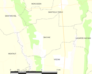
Sauviac and its surrounding communes
Hydrology[]
The Petite Baïse forms part of the commune's eastern border.
Population[]
| Year | Pop. | ±% |
|---|---|---|
| 1962 | 169 | — |
| 1968 | 148 | −12.4% |
| 1975 | 144 | −2.7% |
| 1982 | 130 | −9.7% |
| 1990 | 132 | +1.5% |
| 1999 | 134 | +1.5% |
| 2008 | 110 | −17.9% |
See also[]
- Communes of the Gers department
References[]
- ^ "Répertoire national des élus: les maires". data.gouv.fr, Plateforme ouverte des données publiques françaises (in French). 2 December 2020.
- ^ "Populations légales 2018". INSEE. 28 December 2020.
| Wikimedia Commons has media related to Sauviac (Gers). |
| show Communes of the Gers department |
|---|
This Gers geographical article is a stub. You can help Wikipedia by . |
Categories:
- Communes of Gers
- Gers geography stubs