Vauclusotte
This article includes a list of references, related reading or external links, but its sources remain unclear because it lacks inline citations. (May 2011) |
Vauclusotte | |
|---|---|
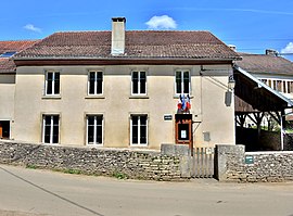 The town hall in Vauclusotte | |
show Location of Vauclusotte | |
 Vauclusotte | |
| Coordinates: 47°16′48″N 6°44′07″E / 47.28°N 6.7353°ECoordinates: 47°16′48″N 6°44′07″E / 47.28°N 6.7353°E | |
| Country | France |
| Region | Bourgogne-Franche-Comté |
| Department | Doubs |
| Arrondissement | Montbéliard |
| Canton | Valdahon |
| Government | |
| • Mayor (2008–2014) | Hubert Briquez |
| Area 1 | 7.62 km2 (2.94 sq mi) |
| Population (Jan. 2018)[1] | 85 |
| • Density | 11/km2 (29/sq mi) |
| Time zone | UTC+01:00 (CET) |
| • Summer (DST) | UTC+02:00 (CEST) |
| INSEE/Postal code | 25589 /25380 |
| Elevation | 395–700 m (1,296–2,297 ft) |
| 1 French Land Register data, which excludes lakes, ponds, glaciers > 1 km2 (0.386 sq mi or 247 acres) and river estuaries. | |


Vauclusotte is a commune in the Doubs département in the Bourgogne-Franche-Comté region in eastern France.
Geography[]
Vauclusotte lies 11 km (6.8 mi) northwest of Maîche near the valley of the Dessoubre.
Population[]
| Year | Pop. | ±% |
|---|---|---|
| 1962 | 145 | — |
| 1968 | 147 | +1.4% |
| 1975 | 136 | −7.5% |
| 1982 | 139 | +2.2% |
| 1990 | 123 | −11.5% |
| 1999 | 110 | −10.6% |
| 2008 | 99 | −10.0% |
| 2012 | 98 | −1.0% |
See also[]
References[]
- ^ "Populations légales 2018". INSEE. 28 December 2020.
External links[]
| Wikimedia Commons has media related to Vauclusotte. |
- Vauclusotte on the regional Web site (in French)
This Doubs geographical article is a stub. You can help Wikipedia by . |
Categories:
- Communes of Doubs
- Doubs geography stubs