Bailleau-le-Pin
Bailleau-le-Pin | |
|---|---|
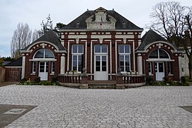 The town hall in Bailleau-le-Pin | |
show Location of Bailleau-le-Pin | |
 Bailleau-le-Pin | |
| Coordinates: 48°22′04″N 1°19′51″E / 48.3678°N 1.3308°ECoordinates: 48°22′04″N 1°19′51″E / 48.3678°N 1.3308°E | |
| Country | France |
| Region | Centre-Val de Loire |
| Department | Eure-et-Loir |
| Arrondissement | Chartres |
| Canton | Illiers-Combray |
| Intercommunality | Entre Beauce et Perche |
| Government | |
| • Mayor (2020–2026) | Martial Lochon |
| Area 1 | 16.54 km2 (6.39 sq mi) |
| Population (Jan. 2018)[1] | 1,558 |
| • Density | 94/km2 (240/sq mi) |
| Time zone | UTC+01:00 (CET) |
| • Summer (DST) | UTC+02:00 (CEST) |
| INSEE/Postal code | 28021 /28120 |
| Elevation | 154–185 m (505–607 ft) (avg. 174 m or 571 ft) |
| 1 French Land Register data, which excludes lakes, ponds, glaciers > 1 km2 (0.386 sq mi or 247 acres) and river estuaries. | |


Bailleau-le-Pin (French pronunciation: [bajo lə pɛ̃]) is a commune in the Eure-et-Loir department in northern France.
Population[]
|
|
See also[]
- Communes of the Eure-et-Loir department
References[]
- ^ "Populations légales 2018". INSEE. 28 December 2020.
| Wikimedia Commons has media related to Bailleau-le-Pin. |
| show Communes of the Eure-et-Loir department of France |
|---|
| show Authority control |
|---|
This Eure-et-Loir geographical article is a stub. You can help Wikipedia by . |
Categories:
- Communes of Eure-et-Loir
- Eure-et-Loir geography stubs