Cluis
Cluis | |
|---|---|
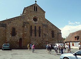 The church of Saint-Paxent, in Cluis | |
 Coat of arms | |
show Location of Cluis | |
 Cluis | |
| Coordinates: 46°32′45″N 1°44′57″E / 46.5458°N 1.7492°ECoordinates: 46°32′45″N 1°44′57″E / 46.5458°N 1.7492°E | |
| Country | France |
| Region | Centre-Val de Loire |
| Department | Indre |
| Arrondissement | La Châtre |
| Canton | Neuvy-Saint-Sépulchre |
| Government | |
| • Mayor (2020–2026) | Didier Fleury |
| Area 1 | 35.32 km2 (13.64 sq mi) |
| Population (Jan. 2018)[1] | 990 |
| • Density | 28/km2 (73/sq mi) |
| Time zone | UTC+01:00 (CET) |
| • Summer (DST) | UTC+02:00 (CEST) |
| INSEE/Postal code | 36056 /36340 |
| Elevation | 188–340 m (617–1,115 ft) (avg. 283 m or 928 ft) |
| 1 French Land Register data, which excludes lakes, ponds, glaciers > 1 km2 (0.386 sq mi or 247 acres) and river estuaries. | |


Cluis (French pronunciation: [klɥi] (![]() listen)) is a commune in the Indre department of the Centre-Val de Loire region of central France.
listen)) is a commune in the Indre department of the Centre-Val de Loire region of central France.
Geography[]
The commune is traversed by the river Bouzanne.
Population[]
|
|
See also[]
- Communes of the Indre department
References[]
- ^ "Populations légales 2018". INSEE. 28 December 2020.
| Wikimedia Commons has media related to Cluis. |
| show Communes of the Indre department |
|---|
This Indre geographical article is a stub. You can help Wikipedia by . |
Categories:
- Communes of Indre
- Indre geography stubs