Montgivray
Montgivray | |
|---|---|
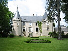 Town hall in the chateau | |
show Location of Montgivray | |
 Montgivray | |
| Coordinates: 46°36′15″N 1°59′00″E / 46.6042°N 1.9833°ECoordinates: 46°36′15″N 1°59′00″E / 46.6042°N 1.9833°E | |
| Country | France |
| Region | Centre-Val de Loire |
| Department | Indre |
| Arrondissement | La Châtre |
| Canton | Neuvy-Saint-Sépulchre |
| Intercommunality | La Châtre et Sainte-Sévère |
| Government | |
| • Mayor (2020–2026) | Michel Blin[1] |
| Area 1 | 25.48 km2 (9.84 sq mi) |
| Population (Jan. 2018)[2] | 1,586 |
| • Density | 62/km2 (160/sq mi) |
| Time zone | UTC+01:00 (CET) |
| • Summer (DST) | UTC+02:00 (CEST) |
| INSEE/Postal code | 36127 /36400 |
| Elevation | 187–253 m (614–830 ft) (avg. 208 m or 682 ft) |
| 1 French Land Register data, which excludes lakes, ponds, glaciers > 1 km2 (0.386 sq mi or 247 acres) and river estuaries. | |


Montgivray (French pronunciation: [mɔ̃ʒivʁɛ] (![]() listen)) is a commune in the Indre department in central France.
listen)) is a commune in the Indre department in central France.
Population[]
|
|
See also[]
- Communes of the Indre department
References[]
- ^ "Répertoire national des élus: les maires". data.gouv.fr, Plateforme ouverte des données publiques françaises (in French). 2 December 2020.
- ^ "Populations légales 2018". INSEE. 28 December 2020.
| Wikimedia Commons has media related to Montgivray. |
| show Communes of the Indre department |
|---|
This Indre geographical article is a stub. You can help Wikipedia by . |
Categories:
- Communes of Indre
- Indre geography stubs