Saint-Gaultier
Saint-Gaultier | |
|---|---|
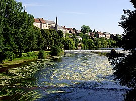 The houses on the banks of the Creuse river | |
 Coat of arms | |
show Location of Saint-Gaultier | |
 Saint-Gaultier | |
| Coordinates: 46°38′10″N 1°25′16″E / 46.6361°N 1.4211°ECoordinates: 46°38′10″N 1°25′16″E / 46.6361°N 1.4211°E | |
| Country | France |
| Region | Centre-Val de Loire |
| Department | Indre |
| Arrondissement | Le Blanc |
| Canton | Saint-Gaultier |
| Intercommunality | Éguzon-Argenton-Vallée de la Creuse |
| Government | |
| • Mayor (2020–2026) | Bruno Chartier |
| Area 1 | 9.20 km2 (3.55 sq mi) |
| Population (Jan. 2018)[1] | 1,811 |
| • Density | 200/km2 (510/sq mi) |
| Time zone | UTC+01:00 (CET) |
| • Summer (DST) | UTC+02:00 (CEST) |
| INSEE/Postal code | 36192 /36800 |
| Elevation | 91–169 m (299–554 ft) (avg. 113 m or 371 ft) |
| 1 French Land Register data, which excludes lakes, ponds, glaciers > 1 km2 (0.386 sq mi or 247 acres) and river estuaries. | |


Saint-Gaultier (French pronunciation: [sɛ̃ gotje] (![]() listen)) is a commune in the Indre department in central France.
listen)) is a commune in the Indre department in central France.
Geography[]
The commune is located in the parc naturel régional de la Brenne.
Population[]
|
|
See also[]
- Communes of the Indre department
References[]
- ^ "Populations légales 2018". INSEE. 28 December 2020.
| Wikimedia Commons has media related to Saint-Gaultier. |
| show Communes of the Indre department |
|---|
| show Authority control |
|---|
This Indre geographical article is a stub. You can help Wikipedia by . |
Categories:
- Communes of Indre
- Indre geography stubs