Saint-Maur, Indre
Saint-Maur | |
|---|---|
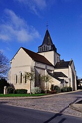 The church in Saint-Maur | |
show Location of Saint-Maur | |
 Saint-Maur | |
| Coordinates: 46°48′27″N 1°38′24″E / 46.8075°N 1.64°ECoordinates: 46°48′27″N 1°38′24″E / 46.8075°N 1.64°E | |
| Country | France |
| Region | Centre-Val de Loire |
| Department | Indre |
| Arrondissement | Châteauroux |
| Canton | Buzançais, Levroux |
| Intercommunality | Châteauroux Métropole |
| Government | |
| • Mayor (2020–2026) | Ludovic Réau |
| Area 1 | 87.91 km2 (33.94 sq mi) |
| Population (Jan. 2018)[1] | 3,654 |
| • Density | 42/km2 (110/sq mi) |
| Time zone | UTC+01:00 (CET) |
| • Summer (DST) | UTC+02:00 (CEST) |
| INSEE/Postal code | 36202 /36250 |
| Elevation | 127–184 m (417–604 ft) (avg. 154 m or 505 ft) |
| 1 French Land Register data, which excludes lakes, ponds, glaciers > 1 km2 (0.386 sq mi or 247 acres) and river estuaries. | |


Saint-Maur (French pronunciation: [sɛ̃ moʁ] (![]() listen)) is a commune in the Indre department in central France. On 1 January 2016, the former commune of Villers-les-Ormes was merged into Saint-Maur.[2]
listen)) is a commune in the Indre department in central France. On 1 January 2016, the former commune of Villers-les-Ormes was merged into Saint-Maur.[2]
Population[]
|
|
See also[]
- Communes of the Indre department
References[]
- ^ "Populations légales 2018". INSEE. 28 December 2020.
- ^ Arrêté préfectoral 11 December 2015 (in French)
| Wikimedia Commons has media related to Saint-Maur (Indre). |
| show Communes of the Indre department |
|---|
This Indre geographical article is a stub. You can help Wikipedia by . |
Categories:
- Communes of Indre
- Indre geography stubs