Sauveterre, Gers
Sauveterre | |
|---|---|
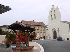 The church and town hall in Sauveterre | |
show Location of Sauveterre | |
 Sauveterre | |
| Coordinates: 43°27′27″N 0°51′29″E / 43.4575°N 0.8581°ECoordinates: 43°27′27″N 0°51′29″E / 43.4575°N 0.8581°E | |
| Country | France |
| Region | Occitanie |
| Department | Gers |
| Arrondissement | Auch |
| Canton | Val de Save |
| Intercommunality | Savès |
| Government | |
| • Mayor (2020–2026) | Bernard Lozes |
| Area 1 | 16.45 km2 (6.35 sq mi) |
| Population (Jan. 2018)[1] | 274 |
| • Density | 17/km2 (43/sq mi) |
| Time zone | UTC+01:00 (CET) |
| • Summer (DST) | UTC+02:00 (CEST) |
| INSEE/Postal code | 32418 /32220 |
| Elevation | 170–311 m (558–1,020 ft) (avg. 260 m or 850 ft) |
| 1 French Land Register data, which excludes lakes, ponds, glaciers > 1 km2 (0.386 sq mi or 247 acres) and river estuaries. | |


Sauveterre (French pronunciation: [sovtɛʁ]; Occitan: Sauvatèrra) is a commune in the Gers department in southwestern France.
Geography[]
Localisation[]

Sauveterre and its surrounding communes
Hydrology[]
The river Gesse forms part of the commune's southern border, then flows into the Save, which forms most of its eastern border.
Population[]
| Year | Pop. | ±% |
|---|---|---|
| 1962 | 364 | — |
| 1968 | 326 | −10.4% |
| 1975 | 283 | −13.2% |
| 1982 | 264 | −6.7% |
| 1990 | 219 | −17.0% |
| 1999 | 229 | +4.6% |
| 2008 | 226 | −1.3% |
See also[]
- Communes of the Gers department
References[]
- ^ "Populations légales 2018". INSEE. 28 December 2020.
| Wikimedia Commons has media related to Sauveterre (Gers). |
| show Communes of the Gers department |
|---|
| show Authority control |
|---|
This Gers geographical article is a stub. You can help Wikipedia by . |
Categories:
- Communes of Gers
- Gers geography stubs