Cuvillers
Cuvillers | |
|---|---|
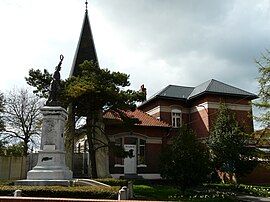 The town hall in Cuvillers | |
 Coat of arms | |
show Location of Cuvillers | |
 Cuvillers | |
| Coordinates: 50°13′23″N 3°14′18″E / 50.2231°N 3.2383°ECoordinates: 50°13′23″N 3°14′18″E / 50.2231°N 3.2383°E | |
| Country | France |
| Region | Hauts-de-France |
| Department | Nord |
| Arrondissement | Cambrai |
| Canton | Cambrai |
| Intercommunality | |
| Government | |
| • Mayor (2014-2020) | Émile Milliot |
| Area 1 | 2.83 km2 (1.09 sq mi) |
| Population (Jan. 2018)[1] | 199 |
| • Density | 70/km2 (180/sq mi) |
| Time zone | UTC+01:00 (CET) |
| • Summer (DST) | UTC+02:00 (CEST) |
| INSEE/Postal code | 59167 /59554 |
| Elevation | 49–74 m (161–243 ft) |
| 1 French Land Register data, which excludes lakes, ponds, glaciers > 1 km2 (0.386 sq mi or 247 acres) and river estuaries. | |


Cuvillers is a commune in the Nord department in northern France.
Heraldry[]
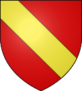 |
The arms of Cuvillers are blazoned : Gules, a bend Or. (the family Duke of Noailles and the communes of Noailles, Cuvillers, Tonnerre, Villespy, Crémarest and Vernoil-le-Fourrier use the same arms.)
|
See also[]
References[]
- ^ "Populations légales 2018". INSEE. 28 December 2020.
| Wikimedia Commons has media related to Cuvillers. |
This Nord geographical article is a stub. You can help Wikipedia by . |
Categories:
- Communes of Nord (French department)
- Nord (French department) geography stubs