Férin
Férin | |
|---|---|
 The town hall in Férin | |
 Coat of arms | |
show Location of Férin | |
 Férin | |
| Coordinates: 50°19′41″N 3°04′26″E / 50.328°N 3.074°ECoordinates: 50°19′41″N 3°04′26″E / 50.328°N 3.074°E | |
| Country | France |
| Region | Hauts-de-France |
| Department | Nord |
| Arrondissement | Douai |
| Canton | Aniche |
| Intercommunality | Douaisis Agglo |
| Government | |
| • Mayor (2014-2020) | Monique Parent |
| Area 1 | 5.52 km2 (2.13 sq mi) |
| Population (Jan. 2018)[1] | 1,469 |
| • Density | 270/km2 (690/sq mi) |
| Time zone | UTC+01:00 (CET) |
| • Summer (DST) | UTC+02:00 (CEST) |
| INSEE/Postal code | 59228 /59169 |
| Elevation | 27–45 m (89–148 ft) (avg. 34 m or 112 ft) |
| 1 French Land Register data, which excludes lakes, ponds, glaciers > 1 km2 (0.386 sq mi or 247 acres) and river estuaries. | |


Férin is a commune in the Nord department in northern France.
It is 4 km (2.5 mi) south of Douai.
Heraldry[]
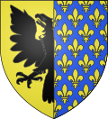 |
The arms of Férin are blazoned : Or, an eagle sable dimidiated with Azure semy de lys Or. The latter being France Ancient (Dechy, Férin and Saint-Saulve use the same arms.)
|
See also[]
References[]
- ^ "Populations légales 2018". INSEE. 28 December 2020.
| Wikimedia Commons has media related to Férin. |
| show Authority control |
|---|
This Nord geographical article is a stub. You can help Wikipedia by . |
Categories:
- Communes of Nord (French department)
- Nord (French department) geography stubs