Lécluse
Lécluse | |
|---|---|
 The town hall in Lécluse | |
 Coat of arms | |
show Location of Lécluse | |
 Lécluse | |
| Coordinates: 50°16′39″N 3°02′31″E / 50.2775°N 3.0419°ECoordinates: 50°16′39″N 3°02′31″E / 50.2775°N 3.0419°E | |
| Country | France |
| Region | Hauts-de-France |
| Department | Nord |
| Arrondissement | Douai |
| Canton | Aniche |
| Intercommunality | Douaisis Agglo |
| Government | |
| • Mayor (2020–2026) | Nicole Descamps-Vottier[1] |
| Area 1 | 4.96 km2 (1.92 sq mi) |
| Population (Jan. 2018)[2] | 1,375 |
| • Density | 280/km2 (720/sq mi) |
| Time zone | UTC+01:00 (CET) |
| • Summer (DST) | UTC+02:00 (CEST) |
| INSEE/Postal code | 59336 /59259 |
| Elevation | 35–75 m (115–246 ft) (avg. 50 m or 160 ft) |
| 1 French Land Register data, which excludes lakes, ponds, glaciers > 1 km2 (0.386 sq mi or 247 acres) and river estuaries. | |


Lécluse (French pronunciation: [leklyz]) is a commune in the Nord department in northern France.
Geography[]
The river Sensée flows through Lécluse.
Heraldry[]
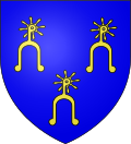 |
The arms of Lécluse are blazoned : Azure, 3 spurs Or, rowel upwards.
|
See also[]
References[]
- ^ "Répertoire national des élus: les maires". data.gouv.fr, Plateforme ouverte des données publiques françaises (in French). 2 December 2020.
- ^ "Populations légales 2018". INSEE. 28 December 2020.
| Wikimedia Commons has media related to Lécluse. |
This Nord geographical article is a stub. You can help Wikipedia by . |
Categories:
- Communes of Nord (French department)
- Nord (French department) geography stubs